Upper Colorado River Type-3 Interagency Incident Management Team
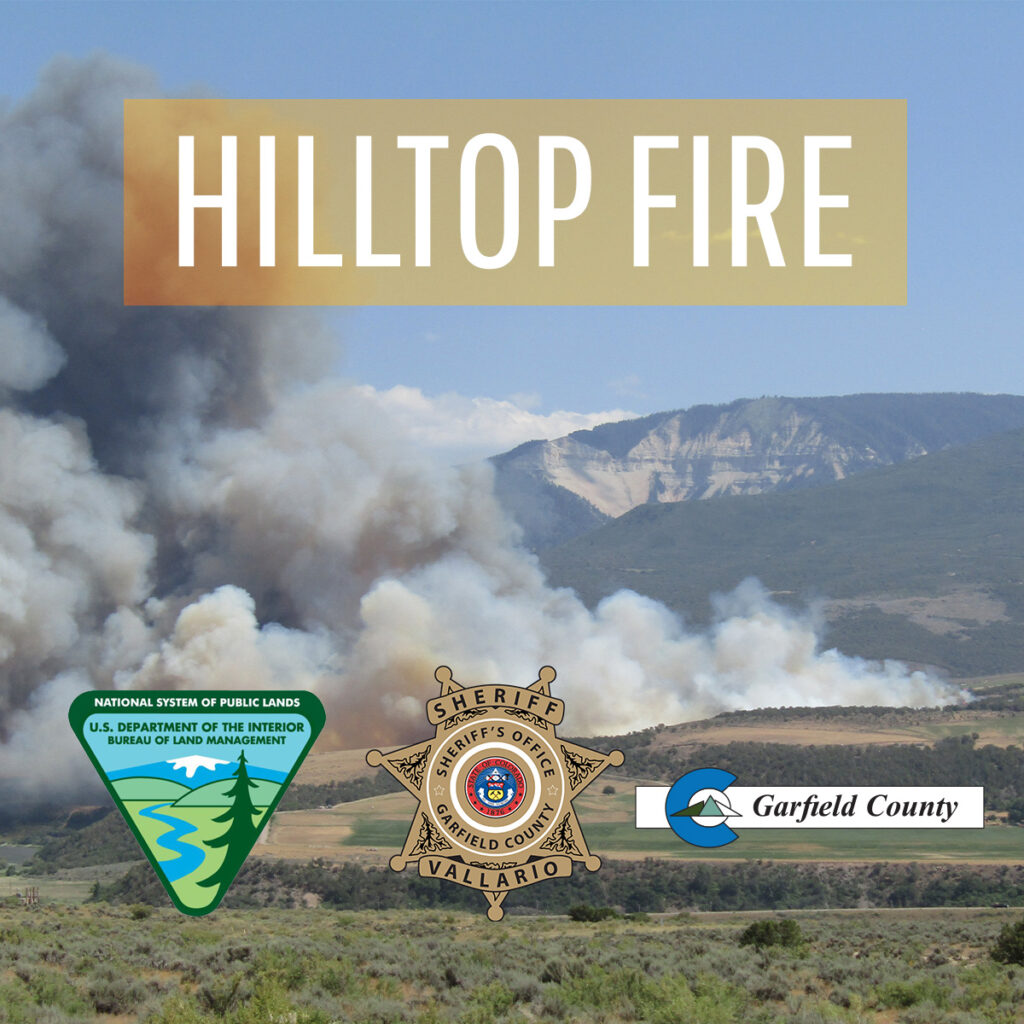
RULISON, CO – The Hilltop Fire has officially been declared contained as of 8 pm tonight. Tomorrow at 7 am, the incident will transition back to a Type 4 Incident Command structure. Remaining resources will continue to patrol, mop-up, and ensure that existing containment lines are secure. The Incident Commander estimates full control tomorrow, June 29th, at 8 pm.
According to Chris Bornholdt, Garfield County Emergency Operations Commander, “Evacuations were lifted last night, and residents were allowed to go back home. We appreciate everyone’s patience throughout this unfortunate event. We would like to thank the firefighters and support personnel from the countless agencies who’ve worked tirelessly to suppress this incident.”
Please note that due to very high fire danger, Stage 1 fire restrictions are currently in effect in unincorporated Garfield County and on lands managed by the Bureau of Land Management and White River National Forest.
Upper Colorado River Type-3 Interagency Incident Management Team
NEWS RELEASE For Immediate Release Media Contact: Renelle Lott, Garfield County Communications Dept., 970.366.2275 June 27, 2025
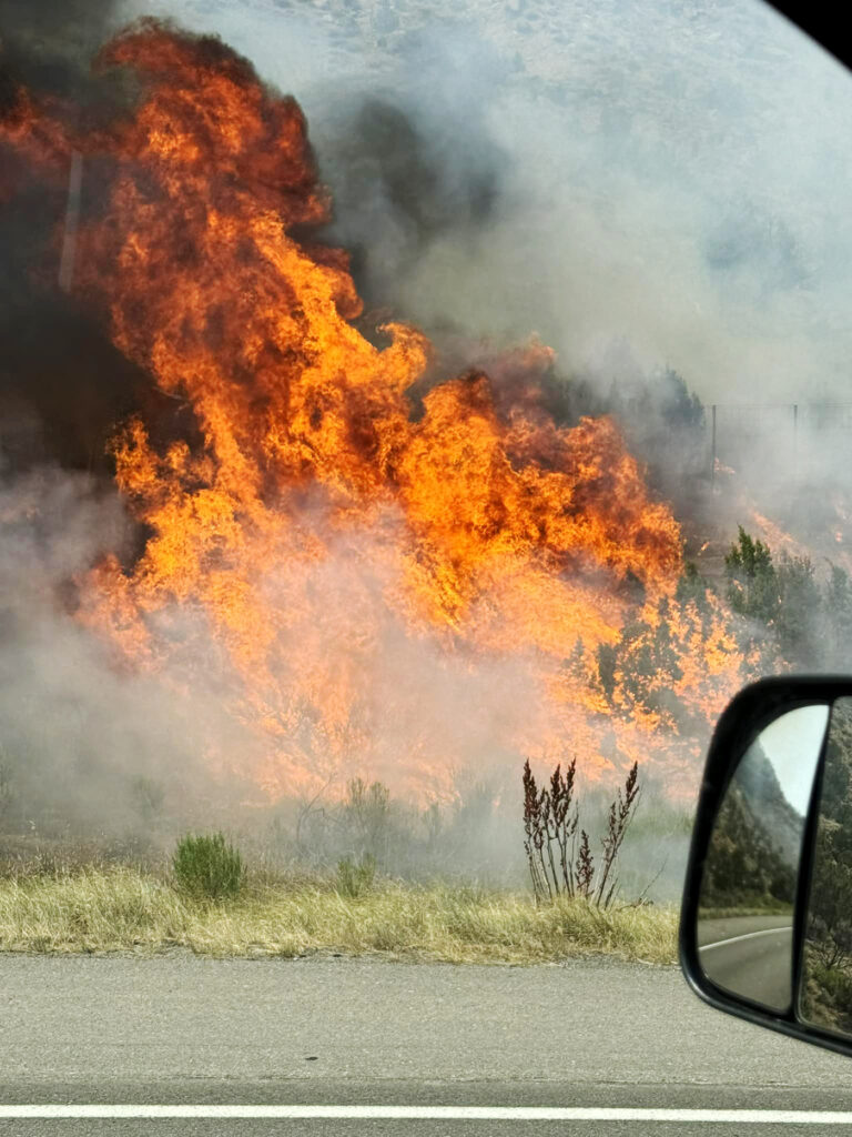
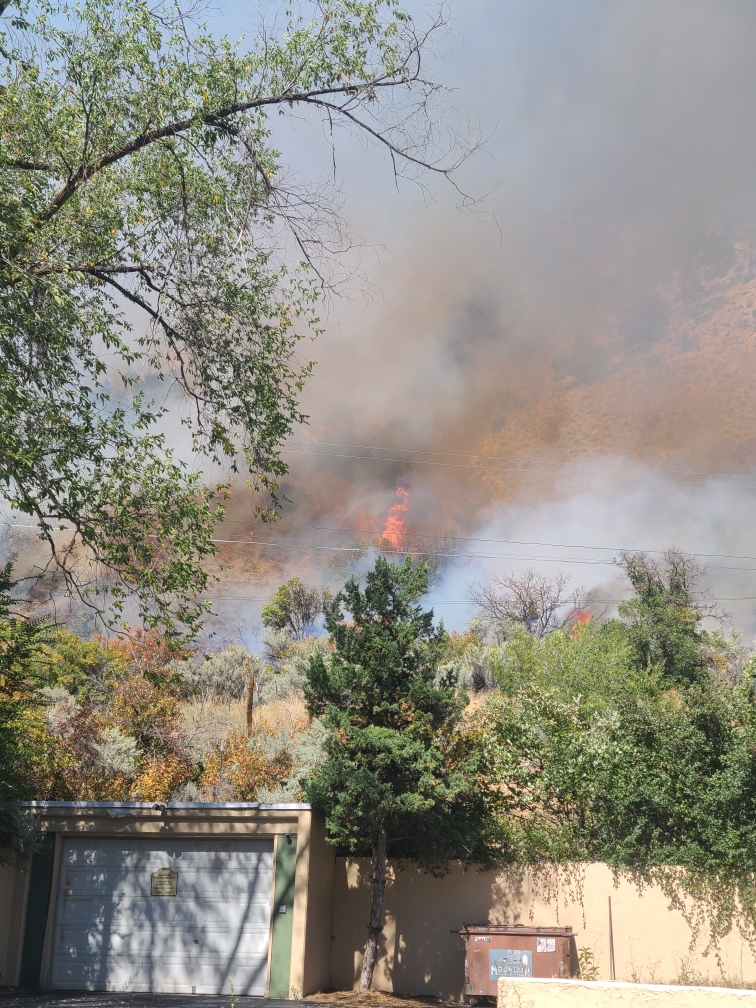
RULISON, CO – Firefighters from multiple agencies continue fire suppression efforts to contain the Hilltop Fire located about 2 miles southeast of Rulison. More accurate mapping indicates the fire is currently at 326 acres and is 40% contained. Approximately 20-25 structures are at risk in the evacuation area.
A total of 153 personnel are currently on-scene. Resources include 13 engines, two type-2 initial attack crews, type-2 wildland fire module, type-2 suppression module, an interagency hot shot crew, smokejumpers, and support personnel.
Upper Colorado River Type-3 Interagency Incident Management Team assumed command this morning. Agencies providing support include Garfield County Sheriff’s Office, Grand Valley Fire Protection District, Colorado River Fire Rescue, Colorado Department of Fire Prevention and Control, Vail Fire Department, Colorado Springs Fire Department, Loveland Fire Department, and Adams County Fire Protection District.
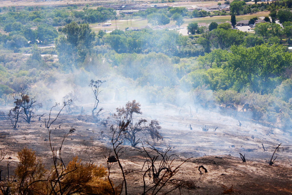
Crews will continue working throughout the weekend to further containment efforts, suppress hot spots and perform mop-up operations. Safety is a priority for firefighters as they work around burned areas and debris, hot spots, and steep slopes.
Evacuations remain in effect for residents located within one mile of County Roads 320 and 309; pre-evacuation continues for residents more than one mile and within two miles of CR 320 and CR 309. Garfield County Sheriff’s Office is helping evacuees access their homes when safely possible.
Power companies are working to restore damaged poles and wires.
The fire investigator determined that this fire was human-caused and preventable. As a reminder, stage 1 fire restrictions are in effect in Garfield County and on lands managed by the Bureau of Land Management and the White River National Forest. The weather is expected to remain hot and dry, with high temps and no moisture throughout the weekend.
We appreciate the support from the community and our partners. In the interest of public and emergency responder safety, please avoid the area.
We will share more information as it becomes available.
UPDATE: Saturday morning, June 28, 2025, it was announced that evacuations are lifted and displaced residents have returned to their homes. Garfield County is assisting with re-entry and recovery.
Garfield County, the Garfield County Sheriff’s Office, Bureau of Land Management (BLM), the U.S. Forest Service, and the seven fire districts in Garfield County are implementing Stage 1 fire restrictions effective at midnight on Thursday, June 26, 2025. This applies to all of Garfield County.
This decision was made with thoughtful consideration. We look at the data, the potential for significant wildfires, and balance it with the impacts to our community. Our concern, with the level of fire danger we are seeing; one spark could quickly spread into a dangerous wildfire threatening lives, property, and natural resources.
Fire restrictions are implemented based on specific criteria, including moisture content of vegetation, weather outlooks, human risk factors, and firefighting resource availability. It has been hot, dry, and unseasonably windy. So far this year, we have had several Red Flag warnings. The National Weather Service is forecasting above average temperatures and dry conditions with no relief from rain anytime soon.
With increasingly dry vegetation, severe drought conditions, and more hot and dry conditions approaching, the danger for human-caused wildfires increases even more.
What Stage I fire restrictions mean in Garfield CountyFireworks are not allowed under Stage I Fire Restrictions. Professional fireworks shows may be allowed through the permitting process.All burn permits are postponed/Canceled until further notice.Campfires are only allowed within designated fire grates in developed areas (i.e. a permanent in-ground containment structure or store bought fire pit) A temporary fire pan and rock campfire rings will not be acceptable.No fires of any type including charcoal in undeveloped areas.No smoking except within a designated area, enclosed vehicle or building, a developed area or in an area free of combustibles.No use of fireworks or explosive materials, including “exploding” targets or bullets and tracer rounds.Exercise common sense and industry safety practice when welding or operation of an acetylene or other similar torch with open flame always cleared safe area of vegetation and combustibles.
Penalties Causing a fire during fire restrictions can be a class 6 felony and can be punishable by fines. Other possible charges range from a Class 2 felony to a petty offense depending on the value of the damage caused. You may be held financially responsible for damage caused.
Federal lands The use of fireworks, flares, or other incendiary devices, including exploding targets, are always prohibited on Federal lands.
By definition: A “developed area” is an area, whether within city limits or rural, that is groomed, manicured and or watered, where grasses, brush and trees are regularly attended to by landowner. This includes residential and business areas, improved recreational areas, parks and other common areas.
An “undeveloped area” are lands that are not groomed, manicured, or watered, where grasses, brush and trees have been allowed to grow in a natural environment. This includes green belts that are not landscaped or manicured, open space lands, non-manicured park lands, and other areas where the fire hazard presented by the vegetation is determined by the authority having jurisdiction or designee to be an undue wildland fire hazard.
U.S. Forest Service and the Bureau of Land Management
White River National Forest and BLM Upper Colorado River District to enact stage 1 fire restrictions
June 25, 2025, 1:04 p.m. – GRAND JUNCTION, Colo. – All lands managed by the White River National Forest and the Bureau of Land Management Upper Colorado River District will be under stage 1 fire restrictions beginning Friday, June 27.
Under stage 1 restrictions for the Bureau of Land Management and White River National Forest:
campfires are only allowed within designated fire grates in developed campgrounds (including the Forest Service Homestake Valley designated dispersed camping sites in Eagle County); this means a metal, in-ground containment structure — fire pans and rock campfire rings are not acceptable.
no fires of any type including charcoal outside of developed areas
no smoking except within an enclosed vehicle or building, a developed recreation site or in a barren area free of vegetation
no use of explosive materials, including explosive targets
no welding or operation of an acetylene or other similar torch with open flame except from an area that has been cleared of vegetation
no operation of any internal combustion engine without a spark arresting device properly installed and in working order
Although conditions vary across the area, a longer-term drying trend is expected to continue.
“Fire restrictions are prudent at this time considering the long-range forecast, fuel moisture conditions on the ground, and the continued high public visitation,” said White River National Forest Supervisor Brian Glaspell. “In developed campgrounds where campfires are permitted, please ensure your fire is completely out and cold before leaving.”
“As we enter stage 1 fire restrictions, it’s crucial for everyone to understand the importance of fire safety during this dry season,” said BLM Upper Colorado River District Manager Greg Larson. “We urge all residents and visitors to be vigilant and responsible with any outdoor activities that could spark a fire. Remember, fireworks are not allowed on federal land.”
Officials consider several criteria when determining the need for fire restrictions, including current and anticipated fire danger, resource availability, and consistency with neighboring jurisdictions. Local, county, state and federal officials within this area evaluate and coordinate fire restrictions weekly during fire season.
BLM Grand Junction and Colorado River Valley Field Offices, part of the BLM Upper Colorado River District, and unincorporated private lands in Eagle, Garfield, Mesa, Pitkin and Summit counties will also enter fire restrictions this week.
On June 18, 2025, the SPEAR task force, with the assistance of the Garfield County All Hazards Response Team (AHRT), executed a narcotics related search warrant at 513 West Ave. in the City of Rifle.
With elements of this case still open, we will hold off on some of the details but wanted the public to know there is no ongoing threat to the community.
SPEAR would like to thank the Garfield County Sheriff’s Office and the Rifle Police Department for their assistance.
SPEAR is a multi-jurisdictional task force based out of the Garfield County, comprised of local and federal law enforcement agencies. Anyone with information on criminal activity is encouraged to reach out to SPEAR through your local law enforcement agency or dispatch at 970 625-8095.
August 22, 2024, 3 p.m. – The Garfield County Sheriff, BLM, and the seven fire districts in Garfield County are lifting Stage 1 Fire Restrictions in all unincorporated areas of Garfield County effective at 12:01 a.m. Friday, August 23, 2024.
The recent rainfall in our area, along with cooler weather, has allowed Stage I Restrictions to be lifted in Garfield County at all elevations. Fire restrictions are implemented based on specific criteria, including the moisture content of vegetation, weather outlooks, human “risk” factors, and firefighting resource availability.
Please exercise due diligence, be careful if you are building a campfire or partaking of any activity in an undeveloped area that might create sparks. There are still a lot of fuels and dry vegetation in Garfield County where a fire could ignite and quickly spread.
Common sense and caution are the rule of the day. Enjoy our great outdoors here in western Colorado, but do so carefully. Starting a wildfire would not only ruin your day, but could cost someone a life, the loss of a home or other personal property. Undoubtedly, there would be legal consequences if you were to start a fire.
AUGUST 22, 2024 – The Bureau of Land Management Upper Colorado River District is removing stage 1 fire restrictions for the Grand Junction and Colorado River Valley Field Offices effective 12:01 a.m. Friday. BLM fire managers, along with agency partners, evaluated current fire danger and predicted weather, and determined that conditions no longer meet the criteria for remaining in fire restrictions.
“We thank the public for their cooperation during fire restrictions this year,” said Acting Upper Colorado River Interagency Fire Management Officer Lathan Johnson. “And we ask that they continue to be fire safe while they enjoy our public lands.”
Although reduced, the risk of wildfires remains.
“Even though we’ve had rain, the threat of fire still exists,” said Johnson. “We encourage our public land users to always use caution while working or recreating outdoors: don’t park in tall, dry grass; when leaving your campfire, put it out with water, stir, and make sure it is cold to the touch; and remember that fireworks are never allowed on public land.”
BLM fire managers will work with local agencies to monitor conditions and evaluate needs for further restrictions. Fire restriction rescission orders for the BLM Upper Colorado River Valley District are available on the district website.
Multi-agency press release from Garfield County Sheriff’s Office
8.14.24, Garfield County, CO – The Garfield County Sheriff, BLM and the seven fire districts in Garfield County are continuing Stage 1 Fire Restrictions in all unincorporated areas of Garfield County effective at 12:01 a.m., Friday, August 16, 2024.
The recent rainfall in our area has allowed the Stage I restrictions to be lifted above the 8000 foot level, however, conditions below that elevation are still at risk due to many of the considerations noted below. These criteria, coupled with the availability of resources due to other fires in Colorado and adjoining states dictates that we continue the Stage I restrictions below the 8000 foot level in Garfield County. Dry vegetation and the severe drought conditions we have recently experienced increases the danger for human-caused wildfires.
The decision was made with thoughtful consideration. We look at the data, the potential for significant wildfires and balance it with the impacts to our community. Our concern, with the level of fire danger we are seeing; one spark could quickly spread into a dangerous wildfire threatening lives, property and natural resources.
Fire restrictions are implemented based on specific criteria to include moisture content of vegetation, weather outlooks, human risk factors and firefighting resource availability. It’s been hot, dry, and unseasonably windy. So far this year, we have had several Red Flag Warnings.
What Stage 1 fire restrictions mean in Garfield County
• Fireworks are not allowed under Stage I Fire Restrictions. Professional fireworks shows may be allowed through the permitting process. • All burn permits are postponed/canceled until further notice. • Campfires are only allowed within designated fire grates in developed areas (i.e. a permanent in-ground containment structure or store-bought fire pit). A temporary fire pan and rock campfire rings will not be acceptable. • No fires of any type, including charcoal, in undeveloped areas. • No smoking except within a designated area, enclosed vehicle or building, a developed area or in an area free of combustibles. • No use of fireworks or explosive materials, including “exploding” targets or bullets and tracer rounds. • Exercise common sense and industry safety practices when welding or operating an acetylene or other similar torch with open flame with a safe area clear of vegetation and combustibles.
Penalties Causing a fire during fire restrictions can be a class 6 felony and can be punishable by fines. Other possible charges range from a Class 2 Felony to a petty offense depending on the value of the damage caused. You may be held financially responsible for damage caused.
Federal lands The use of fireworks, flares, or other incendiary devices, including exploding targets, are always prohibited on federal lands.
By definition:
A “developed area” is an area, whether within city limits or rural, that is groomed, manicured and or watered, where grasses, brush and trees are regularly attended to by the landowner. This includes residential and business areas, improved recreational areas, parks and other common areas.
“Undeveloped areas” are lands that are not groomed, manicured, or watered, where grasses, brush and trees have been allowed to grow in a natural environment. This includes green belts that are not landscaped or manicured, open space lands, non-manicured park lands, and other areas where the fire hazard presented by the vegetation is determined by the authority having jurisdiction or designee to be an undue wildland fire hazard.
Garfield County Sheriff’s Office, BLM, local fire districts
STAGE I FIRE RESTRICTIONS BEGIN AUGUST 2, 2024
Garfield County, CO, The Garfield County Sheriff, BLM and the seven Fire Districts in Garfield County are implementing Stage 1 Fire Restrictions effective at 12:01 a.m. Friday, August 2, 2024. This applies to all of unincorporated Garfield County.
This decision was made with thoughtful consideration. We look at the data, the potential for significant wildfires and balance it with the impacts to our community. Our concern, with the level of fire danger we are seeing; one spark could quickly spread into a dangerous wildfire threatening lives, property and natural resources.
Fire restrictions are implemented based on specific criteria to include moisture content of vegetation, weather outlooks, human risk factors and firefighting resource availability. It’s been hot, dry, and unseasonably windy. So far this year, we have had several Red Flag Warnings. The National Weather Service is forecasting above average temperatures and dry conditions with no relief from rain anytime soon.
With increasingly dry vegetation, severe drought conditions, and more hot and dry conditions approaching, the danger for human caused wildfires increases even more.
WHAT STAGE I FIRE RESTRICTIONS MEAN IN GARFIELD COUNTY
Fireworks are not allowed under Stage I Fire Restrictions. Professional fireworks shows may be allowed through the permitting process.
All burn permits are postponed/Canceled until further notice.
Campfires are only allowed within designated fire grates in Developed Areas (i.e. a permanent in-ground containment structure or store bought fire pit) A temporary fire pan and rock campfire rings will not be acceptable.
No fires of any type including charcoal in Undeveloped Areas.
No smoking except within a designated area, enclosed vehicle or building, a developed area or in an area free of combustibles.
No use of fireworks or explosive materials, including “exploding” targets or bullets and tracer rounds.
Exercise common sense and industry safety practice when welding or operation of an acetylene or other similar torch with open flame always cleared safe area of vegetation and combustibles.
Penalties
Causing a fire during fire restrictions can be a class 6 felony and can be punishable by fines. Other possible charges range from a Class 2 Felony to a petty offense depending on the value of the damage caused. You may be held financially responsible for damage caused.
Federal Lands
The use of fireworks, flares, or other incendiary devices, including exploding targets, are always prohibited on federal lands.
By Definition:
A “Developed Area” is an area, whether within city limits or rural, that is groomed, manicured and or watered, where grasses, brush and trees are regularly attended to by land owner. This includes residential and business areas, improved recreational areas, parks and other common areas.
An “Undeveloped Area” are lands that are not groomed, manicured, or watered, where grasses, brush and trees have been allowed to grow in a natural environment. This includes green belts that are not landscaped or manicured, open space lands, non-manicured park lands, and other areas where the fire hazard presented by the vegetation is determined by the authority having jurisdiction or designee to be an undue wildland fire hazard.
July 22, 2024, 3:43 p.m. – Interstate 70 closed between mile markers 81 and 87 (West Rifle exit to Rulison) due to brush fire.
July 22, 2024, 3:25 p.m. – Colorado River Fire Rescue (CRFR) crews along with Grand Valley Fire Protection District and Upper Colorado River Interagency Fire Management Unit are on the scene of multiple fires along I-70 starting at mile marker 87 westbound. I-70 westbound (West Rifle exit) is closed. Please stay away from the frontage roads and avoid the area.
Morissania Mesa Fire Management returned to the Grand Valley Fire Protection District
10.3.23, 7:40 p.m. – GARFIELD COUNTY, CO. – Containment of the Morrisania Mesa Fire stands at 85% as of this evening. During the fire, which started Saturday evening September 30, one house was lost at 2879 County Road 301 and one large shop, both owned by the same family.
Incident Commander Chris Bornholdt with Garfield County Emergency Services will be turning control and management of the fire back over to the Grand Valley Fire Protection District as of midnight tonight. The County assumed control and management of the fire Saturday night through Emergency Services Commander Bornholdt. It was determined that the rapid growth of the fire would require additional resources and people power on the ground and in the air. The county stepped up in this instance because the resources that would be needed are not readily available to local districts or are cost prohibitive. The final goal was to minimize the spread of the fire and protect property and residents in the area.
In the final analysis, the fire turned out to be 61 acres, not the originally estimated 100 acres. Grand River Fire District will monitor the fire until it can be categorized as 100% contained.
This will be the final press release from Garfield County concerning the Morissania Mesa Fire. Thanks to all who assisted and to the residents of Garfield County for their cooperation and assistance in this matter.
Morrisania Mesa (Rulison) Fire update
10.3.23, 10:01 a.m. – As of Monday evening October 2, 2023, the Morrisania Fire is 75% contained. All evacuation orders have been lifted, but residents in the area still need to be on high alert.
The road closures have been lifted as of this Tuesday Morning October 3, but please stay out of the area, as fire equipment is still moving around working the fire. Residents are free to move their livestock back into the area today.
There has been no fire growth over the past couple days. The fire is estimated at 100 acres, we will have numbers that are more accurate this afternoon.
There are 15 firefighters working the fire today and checking for hot spots. Today’s teams include the Rocky Mountain National Park MOD 32, Grand Valley Fire Protection District and the Garfield County Sheriff’s Office.
The Garfield County Sheriff’s Office wants to thank the residents of Garfield County for their continued cooperation in this matter and their support of all our first responders.
Residence Lost in Rulison Fire at 2879 County Road 301
10.1.23, 6:40 p.m. – On Saturday evening, Sept. 30, 2023, several fires started in Garfield County due to lightning strikes. Most of the fires were limited in scope to a single tree and/or the area immediately surrounding the tree. One fire began near the 3-mile mark on CR 301 near Rulison. Some residents lost power and others were directed to evacuate due to the proximity of their residences to the fire.
Grand Valley Fire Protection District Fire responded immediately and worked to protect existing structures and properties as well as assure the safety of the residents. Unfortunately, one home was lost as the firefighters were forced to withdraw due to the intensity of the blaze.
By early Sunday morning, at 12:30 a.m., deputies were clearing the area. Two unmanned road closures, one at the intersections of County Road 301 and CR 309 and a second closure at the intersection of CR 301 and CR 355. The Garfield County Fairgrounds were made available to residents to receive any livestock or other animals from the area that needed to be housed until the fire could be contained.
A briefing was held on Sunday at 7 a.m. Mutual aid came from several sources including Colorado River Fire Rescue, De Beque Fire, the Vail Fire Department, Interagency Fire, the Greater Eagle Fire District, Carbondale Fire, and Aspen Fire.
Air resources were ordered by Incident Commander Chris Bornholdt. Various airdrops were made beginning at 10 a.m. on Sunday with the idea to minimize the spread of the fire by establishing a perimeter.
By 4 p.m. Sunday, it was reported that the area residents have been down-graded to a “pre-evacuation” status meaning residents could be at home but should be prepared to evacuate on short notice should conditions change. The fire is currently at approximately 100 acres and holding. There is 0% containment at this time with 102 firefighters on scene between ground and aircrews.
Grand Valley Fire Protection District
10.1.23, 10:03 am – The fire is currently approximately 200 acres. We have a multitude of ground resources en route. Operations are unified command with Garfield County Sheriff’s Office. Two helicopters are currently flying overhead. Please limit traffic on County Road 301 and County Road 309. Evacuation orders are also still in place between County Road 301 and 309. We will post updates as often as possible with new information. Grand Valley Fire Protection District facebook
Garfield County Sheriff’s Office
9.30.23, 9:53 pm – Lightning strike resulting in fire on Morrisania Mesa (County Road 301 at mile marker 3). Please stay away from this area and let the first responders do their job. Garfield County Fairgrounds is open to animals displaced by the fire. Garfield County Sheriff’s Office facebook
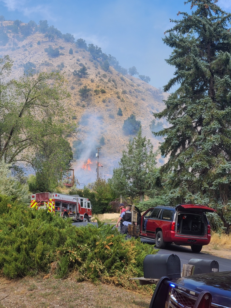
9.24.23, 10:26 am – Glenwood Springs, Colorado – The prompt and coordinated efforts of multiple agencies successfully prevented the Mountain Shadows Fire from causing damage to nearby residential structures. As a result, residents were able to safely return to their homes after being evacuated due to the brush fire.
At approximately 1:33 p.m. on Saturday, September 23rd, the Glenwood Springs Fire Department was called to a brush fire in West Glenwood. Upon arrival, firefighters discovered an active blaze covering an acre of land, accompanied by heavy smoke. The fire was being pushed towards the east by strong westerly winds. Firefighters swiftly identified structures at risk and collaborated with the Garfield County Sheriff’s Office to address evacuation concerns, all while actively fighting the fire. Thanks to the efforts of the Garfield County Sheriff, threatened structures were safely evacuated.
Securing the fire line closest to the residential area was a priority for the firefighters. Their successful efforts in doing so allowed for the lifting of evacuation orders before evening.
The current size of the fire is approximately 4. 5 acres. The Glenwood Springs Fire Department monitored the fire throughout the night and will continue mop-up operations today.
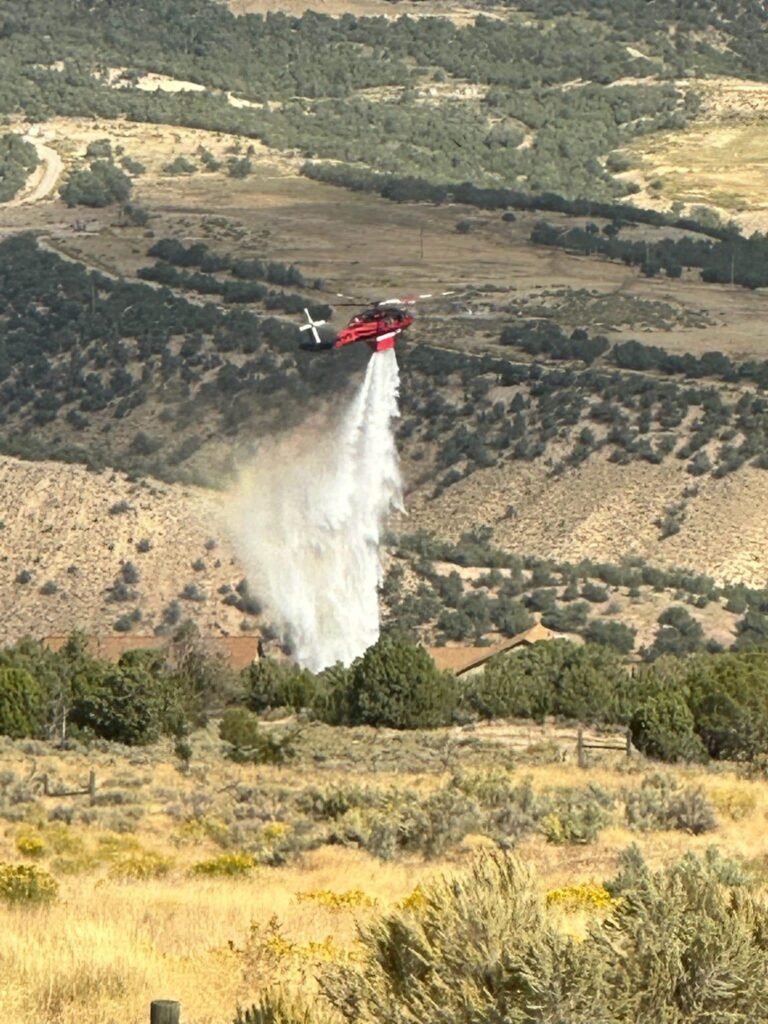
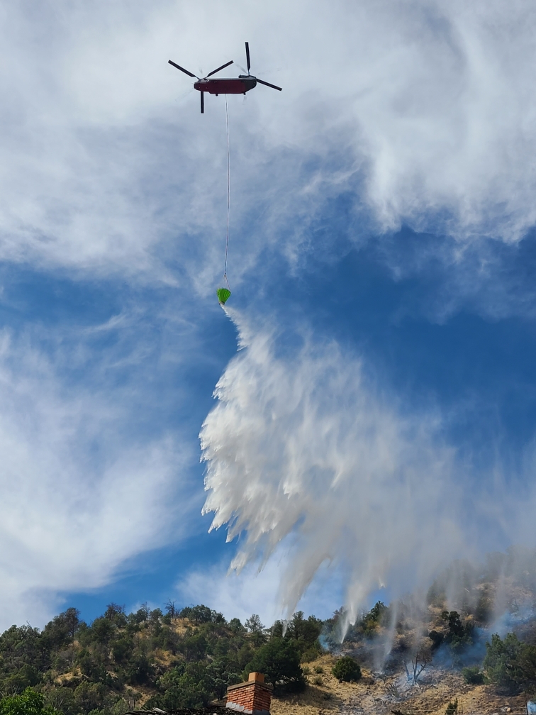
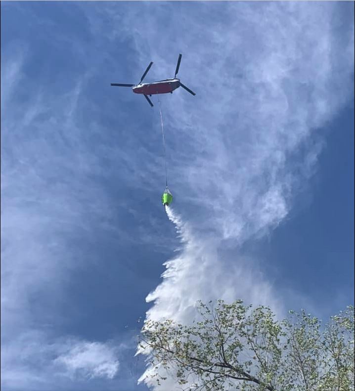
According to Incident Commander Jesse Hood, “Quick action from initial attack and mutual aid resources were paramount in the suppression of this fire. The utilization of air resources gave command insight into fire behavior and helicopter bucket drops cooled hot spots so ground crews could access and extinguish as the terrain was steep.”
In response to the incident, a total of 5 engines, 1 water tender, 1 command vehicle, 2 investigation vehicles, a Chinook helicopter, a multi-mission aircraft, air attack, and two ambulances, along with over 30 firefighters, were deployed from Colorado River Fire Rescue, Carbondale and Rural Fire Protection District, Roaring Fork Fire Authority, and the Upper Colorado Fire Management Unit. Additionally, the Colorado State Patrol, Garfield County Sheriff’s Office, Glenwood Springs Police Department, and Glenwood Electric all responded to this incident. The water supply for the Chinook helicopter was provided by Storm King Ranch. The Glenwood Springs Fire Department is immensely grateful for the response from these partner agencies.
No injuries have been reported at this time.
The cause of the fire is currently under investigation by the Garfield County Fire Investigation Team, in collaboration with the Glenwood Springs Fire Department.
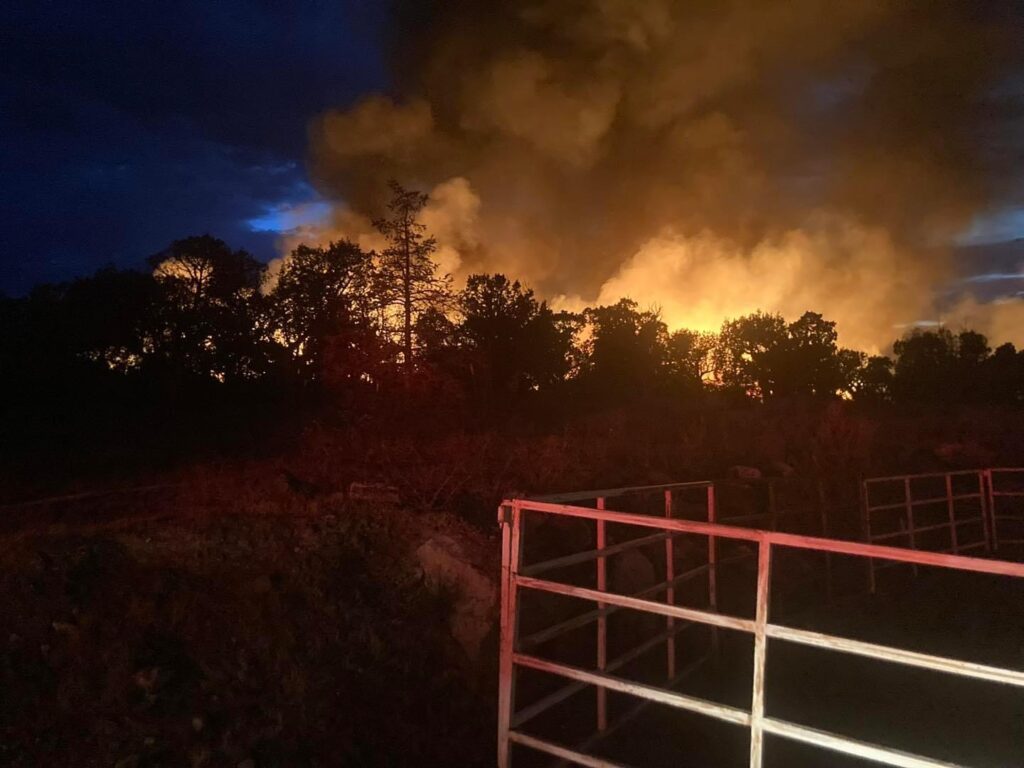
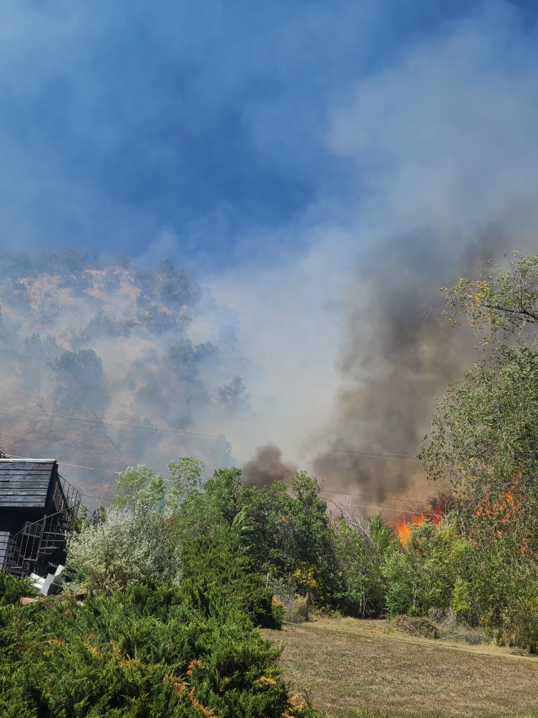
Flames behind homes in West Glenwood Sept. 23, 2023Flames behind homes in West Glenwood Sept. 23, 2023Flames behind structures in West Glenwood Sept. 23, 2023Heli attack in West Glenwood Sept. 23, 2023
Garfield County Sheriff’s Office
9.23.23, 4:57 pm – Evacuation are lifted and roadblocks open, except no driving onto Mt Shadows Dr. Residents may walk in. Garfield County Sheriff’s Office facebook
Brush fire in West Glenwood Springs with structures threatened. Active flames and smoke visible. Please stay away from this area and allow first responders to do their job.