12.8.23, 2:41 p.m. – Between exit 114: West Glenwood (Glenwood Springs) and Exit 129: Bair Ranch (7 miles west of Dotsero) from Mile Point 116 to Mile Point 126. Road closed expect delays due to a crash.
Comment: Pileup eastbound at Hanging Lake Tunnel. I-70 closed at Glenwood Springs.
Check CDOT cotrip for closures for updates when traveling.
12-8-23, 12:50 p.m. – Comment:At least 18 vehicles involved in pileup.
12-8-23, 11:13 a.m. – Interstate 70 is closed westbound between Exit 72: West Parachute (2 miles west of Parachute) and Exit 62: De Beque (De Beque) from Mile Point 72 to Mile Point 62. Road closed expect delays due to a crash.
I-70 through Glenwood Springs is completely open now. The collision scene has been cleared. Travel cautiously in the current severe weather conditions.
Colorado Department of Transportation
12-8-23, 11:39 a.m. – At Exit 114: West Glenwood (Glenwood Springs) at Mile Point 114.2. Road closed expect delays due to a crash. Slower speeds are advised.
Comment: Eastbound traffic being diverted around crash using the Exit 114 off-ramp and on-ramp.
12-8-23, 10:49 a.m. – Interstate 70 is closed in both directions in South Canyon between Exit 114: West Glenwood and Exit 111: South Canyon (Glenwood Springs) at Mile Point 114. Road closed expect delays due to a crash. Slower speeds are advised.
The Colorado Avalanche Information Center (CAIC) and the Avalanche Research Program of Simon Fraser University in Canada are building SNOW POOL, a community of backcountry users interested in providing feedback about their backcountry experiences and willing to review, share feedback, and provide suggestions about how to make avalanche safety information work better for everybody.
Who should sign up?
You do not have to live in Colorado or have any avalanche knowledge to participate. We are interested in the perspectives of all types of users with all levels of experience. We are especially interested in hearing from individuals who are just starting their backcountry adventures or only occasionally go into the backcountry.
What can participants expect?
Individuals who sign up will receive regular emails from CAIC and SFU to participate in short online user surveys and the opportunity to provide feedback on CAIC products and priorities. This is an opportunity to be part of a community that contributes to the development of improved avalanche risk communication, learn about CAIC research projects, and be eligible for incentive programs or entered into raffles hosted by some of our partners.
Morissania Mesa Fire Management returned to the Grand Valley Fire Protection District
10.3.23, 7:40 p.m. – GARFIELD COUNTY, CO. – Containment of the Morrisania Mesa Fire stands at 85% as of this evening. During the fire, which started Saturday evening September 30, one house was lost at 2879 County Road 301 and one large shop, both owned by the same family.
Incident Commander Chris Bornholdt with Garfield County Emergency Services will be turning control and management of the fire back over to the Grand Valley Fire Protection District as of midnight tonight. The County assumed control and management of the fire Saturday night through Emergency Services Commander Bornholdt. It was determined that the rapid growth of the fire would require additional resources and people power on the ground and in the air. The county stepped up in this instance because the resources that would be needed are not readily available to local districts or are cost prohibitive. The final goal was to minimize the spread of the fire and protect property and residents in the area.
In the final analysis, the fire turned out to be 61 acres, not the originally estimated 100 acres. Grand River Fire District will monitor the fire until it can be categorized as 100% contained.
This will be the final press release from Garfield County concerning the Morissania Mesa Fire. Thanks to all who assisted and to the residents of Garfield County for their cooperation and assistance in this matter.
Morrisania Mesa (Rulison) Fire update
10.3.23, 10:01 a.m. – As of Monday evening October 2, 2023, the Morrisania Fire is 75% contained. All evacuation orders have been lifted, but residents in the area still need to be on high alert.
The road closures have been lifted as of this Tuesday Morning October 3, but please stay out of the area, as fire equipment is still moving around working the fire. Residents are free to move their livestock back into the area today.
There has been no fire growth over the past couple days. The fire is estimated at 100 acres, we will have numbers that are more accurate this afternoon.
There are 15 firefighters working the fire today and checking for hot spots. Today’s teams include the Rocky Mountain National Park MOD 32, Grand Valley Fire Protection District and the Garfield County Sheriff’s Office.
The Garfield County Sheriff’s Office wants to thank the residents of Garfield County for their continued cooperation in this matter and their support of all our first responders.
Residence Lost in Rulison Fire at 2879 County Road 301
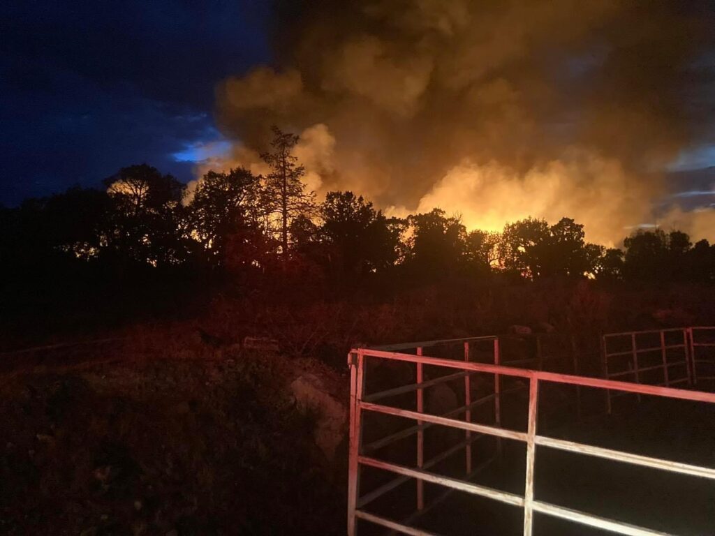
10.1.23, 6:40 p.m. – On Saturday evening, Sept. 30, 2023, several fires started in Garfield County due to lightning strikes. Most of the fires were limited in scope to a single tree and/or the area immediately surrounding the tree. One fire began near the 3-mile mark on CR 301 near Rulison. Some residents lost power and others were directed to evacuate due to the proximity of their residences to the fire.
Grand Valley Fire Protection District Fire responded immediately and worked to protect existing structures and properties as well as assure the safety of the residents. Unfortunately, one home was lost as the firefighters were forced to withdraw due to the intensity of the blaze.
By early Sunday morning, at 12:30 a.m., deputies were clearing the area. Two unmanned road closures, one at the intersections of County Road 301 and CR 309 and a second closure at the intersection of CR 301 and CR 355. The Garfield County Fairgrounds were made available to residents to receive any livestock or other animals from the area that needed to be housed until the fire could be contained.
A briefing was held on Sunday at 7 a.m. Mutual aid came from several sources including Colorado River Fire Rescue, De Beque Fire, the Vail Fire Department, Interagency Fire, the Greater Eagle Fire District, Carbondale Fire, and Aspen Fire.
Air resources were ordered by Incident Commander Chris Bornholdt. Various airdrops were made beginning at 10 a.m. on Sunday with the idea to minimize the spread of the fire by establishing a perimeter.
By 4 p.m. Sunday, it was reported that the area residents have been down-graded to a “pre-evacuation” status meaning residents could be at home but should be prepared to evacuate on short notice should conditions change. The fire is currently at approximately 100 acres and holding. There is 0% containment at this time with 102 firefighters on scene between ground and aircrews.
Grand Valley Fire Protection District
10.1.23, 10:03 am – The fire is currently approximately 200 acres. We have a multitude of ground resources en route. Operations are unified command with Garfield County Sheriff’s Office. Two helicopters are currently flying overhead. Please limit traffic on County Road 301 and County Road 309. Evacuation orders are also still in place between County Road 301 and 309. We will post updates as often as possible with new information. Grand Valley Fire Protection District facebook
Garfield County Sheriff’s Office
9.30.23, 9:53 pm – Lightning strike resulting in fire on Morrisania Mesa (County Road 301 at mile marker 3). Please stay away from this area and let the first responders do their job. Garfield County Fairgrounds is open to animals displaced by the fire. Garfield County Sheriff’s Office facebook
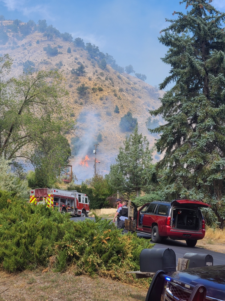
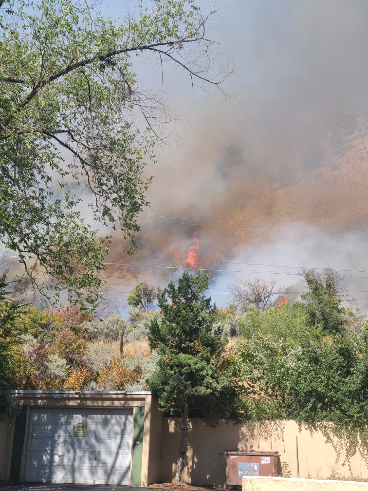
9.24.23, 10:26 am – Glenwood Springs, Colorado – The prompt and coordinated efforts of multiple agencies successfully prevented the Mountain Shadows Fire from causing damage to nearby residential structures. As a result, residents were able to safely return to their homes after being evacuated due to the brush fire.
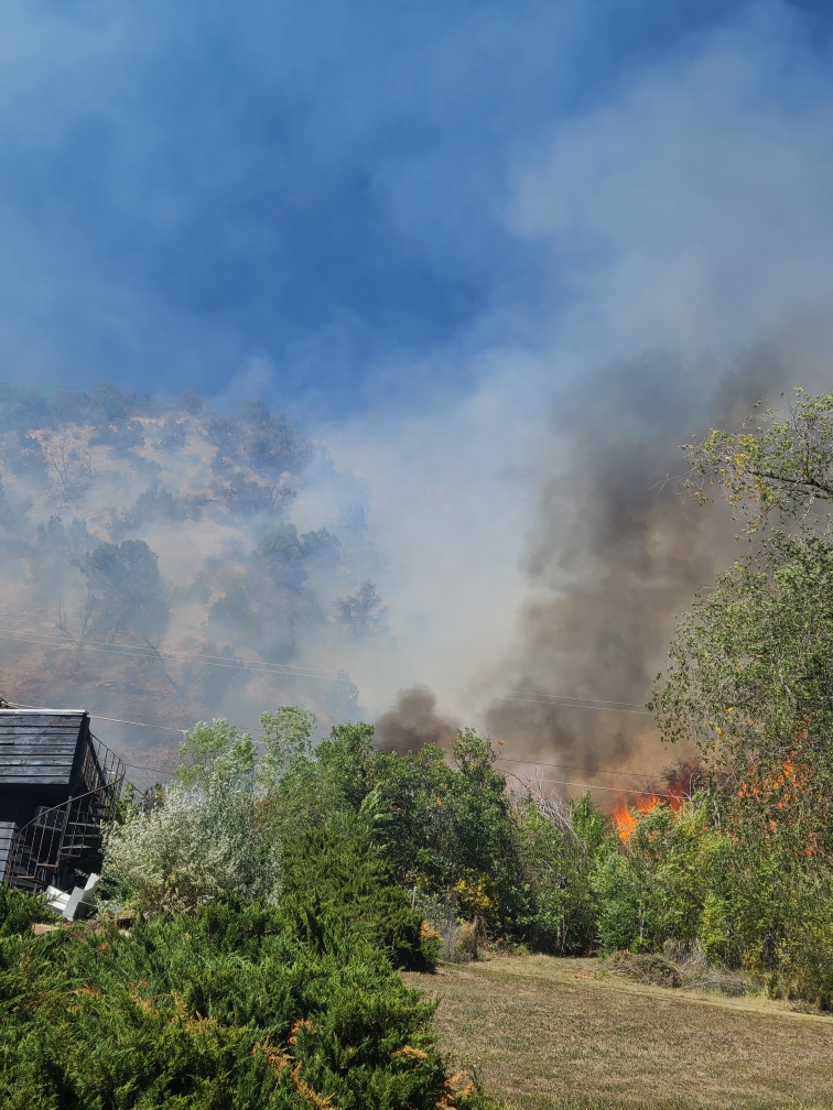
At approximately 1:33 p.m. on Saturday, September 23rd, the Glenwood Springs Fire Department was called to a brush fire in West Glenwood. Upon arrival, firefighters discovered an active blaze covering an acre of land, accompanied by heavy smoke. The fire was being pushed towards the east by strong westerly winds. Firefighters swiftly identified structures at risk and collaborated with the Garfield County Sheriff’s Office to address evacuation concerns, all while actively fighting the fire. Thanks to the efforts of the Garfield County Sheriff, threatened structures were safely evacuated.
Securing the fire line closest to the residential area was a priority for the firefighters. Their successful efforts in doing so allowed for the lifting of evacuation orders before evening.
The current size of the fire is approximately 4. 5 acres. The Glenwood Springs Fire Department monitored the fire throughout the night and will continue mop-up operations today.
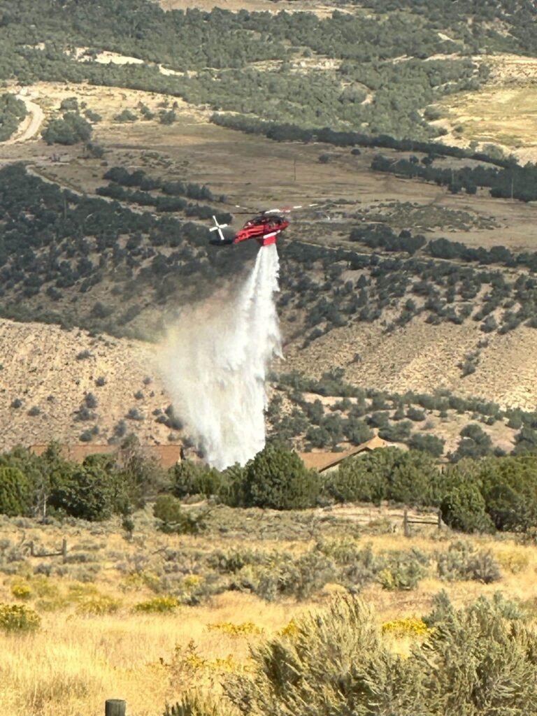
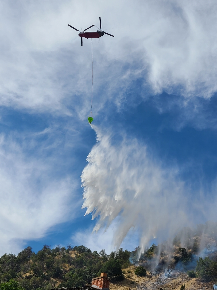
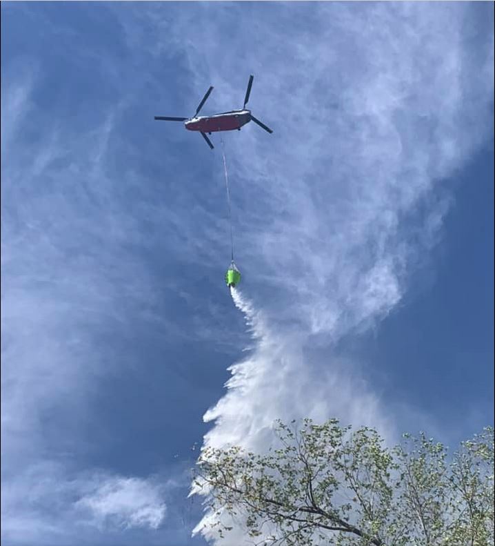
According to Incident Commander Jesse Hood, “Quick action from initial attack and mutual aid resources were paramount in the suppression of this fire. The utilization of air resources gave command insight into fire behavior and helicopter bucket drops cooled hot spots so ground crews could access and extinguish as the terrain was steep.”
In response to the incident, a total of 5 engines, 1 water tender, 1 command vehicle, 2 investigation vehicles, a Chinook helicopter, a multi-mission aircraft, air attack, and two ambulances, along with over 30 firefighters, were deployed from Colorado River Fire Rescue, Carbondale and Rural Fire Protection District, Roaring Fork Fire Authority, and the Upper Colorado Fire Management Unit. Additionally, the Colorado State Patrol, Garfield County Sheriff’s Office, Glenwood Springs Police Department, and Glenwood Electric all responded to this incident. The water supply for the Chinook helicopter was provided by Storm King Ranch. The Glenwood Springs Fire Department is immensely grateful for the response from these partner agencies.
No injuries have been reported at this time.
The cause of the fire is currently under investigation by the Garfield County Fire Investigation Team, in collaboration with the Glenwood Springs Fire Department.
Flames behind homes in West Glenwood Sept. 23, 2023Flames behind homes in West Glenwood Sept. 23, 2023Flames behind structures in West Glenwood Sept. 23, 2023Heli attack in West Glenwood Sept. 23, 2023
Garfield County Sheriff’s Office
9.23.23, 4:57 pm – Evacuation are lifted and roadblocks open, except no driving onto Mt Shadows Dr. Residents may walk in. Garfield County Sheriff’s Office facebook
Brush fire in West Glenwood Springs with structures threatened. Active flames and smoke visible. Please stay away from this area and allow first responders to do their job.
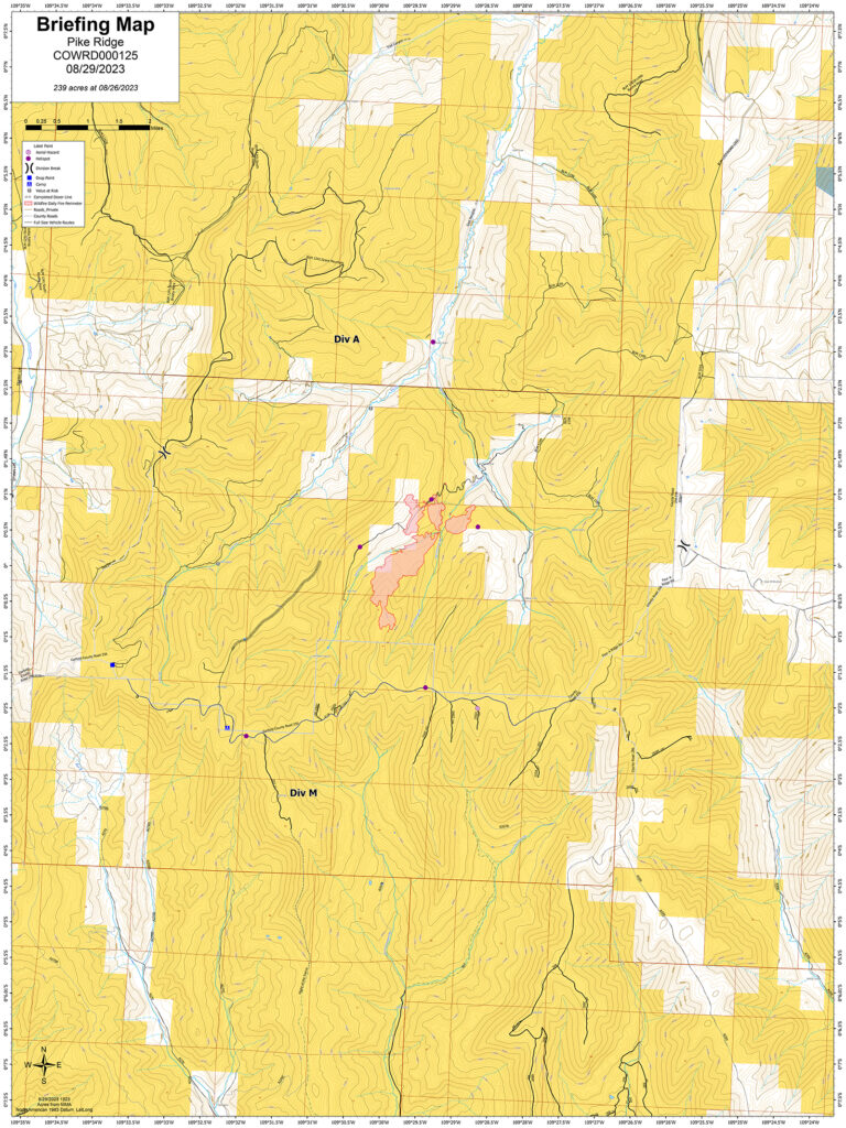
Contact: Patrick Kieran Public Information Officer (720) 679-4234 Location: Approximately 28 miles North of Loma, Colorado. Jurisdiction: Bureau of Land Management, Grand Junction Field Office, and White River Field Office, Private. Discovered: 08/12/2023 01:52 p.m. Cause: Lightning Vegetation type: Beetle Kill Spruce/Conifer, Mountain Brush Estimated size: 246 acres Containment: 65% Threatened structures: 1 Historical Homestead Current status: Increased showers expected over the fire area. The Northern Utah Type 3 Interagency Management Team has command of this fire. Fire suppression actions continue while maintaining safety for the public and firefighters. Current size is 246 acres, burning in a decadent Spruce/Conifer beetle kill Forest. Less than 60 fire personal comprising of Aviation, Crews, Engines, and Overhead. Planned actions: The Northern Utah Type 3 Interagency Management Team will transition command of the Pike Ridge Fire back to Northwest District Fire on Monday, 9/11. Fire resources continue to build direct fire line when targets of suppression opportunity are possible. Mop up of the fire perimeter is ongoing. Structure protection of non-occupied historic homestead is complete. Hand Crews and Engines are preparing County Roads as a holding feature. Resources are removing vegetation along roads to lessen fire intensity if these County Roads need to be ignited to perform a burnout operation. The use of mechanical equipment has assisted this process. Fire and Land Managers are constantly assessing resources, communications, and working partnerships while ensuring public and firefighter safety. Evacuations and closures: No evacuations. Closures: No closures. Smoke: Smoke will be visible from the Grand Valley, Meeker and Rangely, Co areas. Smoke is not impacting any roadway directly. Go to www.airnow.gov to view local airsheds and National Smoke Report. Aviation safety: Aircraft may be used over the Pike Ridge Fire air space. Fire aviation resources are flying at different altitudes and speeds. Pilots should exercise caution when flying near wildfires to keep everyone safe. Temporary Flight Restriction (TFR) FDC 3/9155 is in place through 09/22/2023. Unmanned aircraft systems (UAS) or drones must never fly near wildfires, as UAS are difficult to see and drone pilots have no way of communicating with firefighting aircraft. The only UAS or drones able to fly are agency owned and operated and have been assigned to work on the wildfire and have communication with air operations. Remember if you fly, we can’t!
Contact: Patrick Kieran, Public Information Officer (720) 679-4234 Location: Approximately 28 miles North of Loma, Colorado. Jurisdiction: Bureau of Land Management, Grand Junction Field Office, and White River Field Office, Private. Discovered: 08/12/2023 01:52 p.m. Cause: Lightning Vegetation type: Beetle Kill Spruce/Conifer, Mountain Brush Estimated size: 242 acres. Containment: 0% Threatened structures: 1 historical homestead Current status: Weather conditions are drying out and wind gusts of 25 mph are anticipated for Wednesday afternoon. The next round of Monsoon moisture is Friday through the weekend. Some smoke can be seen in the area. The Northern Utah Type 3 Interagency Management Team has completed Transfer of Command on Tuesday, 08/29. Fire suppression actions continue while maintaining safety for the public and firefighters. Current size is 242 acres, burning in a decadent Spruce/Conifer beetle kill Forest. There are now over 120 fire personal comprising of Aviation, Crews, Engines, and Overhead.
Planned actions: Structure protection of non-occupied historic homestead are complete. Suppression actions are ongoing. The Hand Crews and Engines are preparing County Roads as a holding feature. They are removing vegetation along roads to lessen fire intensity if these County Roads need to be ignited to perform a burnout operation. The assistance of a mechanical masticator has sped up the process. Fire and Land Managers are constantly assessing resources, communications, and working partnerships while ensuring public and firefighter safety.
Evacuations and closures: No evacuations.
Closures: To protect persons, property, public lands, and resources these roads are closed to all public use to support the Pike Ridge Fire. BLM lands within Garfield and Rio Blanco Counties. Public lands within ¼ mile south of Garfield County Road 256, East of Pike Ridge, and West of Garfield County Road 257.
Smoke: Smoke will be visible from the Grand Valley, Meeker and Rangely, Co areas. Travelers on Highway 139 from Loma, CO to Rangely, CO will see the most some. Smoke is not impacting any roadway directly. Go to airnow.gov to view local airsheds and national smoke report.
Aviation safety: Aircraft may be used over the Pike Ridge Fire air space. Fire aviation resources are flying at different altitudes and speeds. Pilots should exercise caution when flying near wildfires to keep everyone safe. Temporary Flight Restriction (TFR) FDC 3/9155 is in place through 09/22/2023. Unmanned aircraft systems (UAS) or drones must never fly near wildfires, as UAS are difficult to see and drone pilots have no way of communicating with firefighting aircraft. The only UAS or drones able to fly are agency owned and operated and have been assigned to work on the wildfire and have communication with air operations. Remember if you fly, we can’t!