Colorado Avalanche Information Center and National Weather Service
SPECIAL AVALANCHE ADVISORY
BULLETIN – IMMEDIATE BROADCAST REQUESTED
COLORADO AVALANCHE INFORMATION CENTER
RELAYED BY NATIONAL WEATHER SERVICE DENVER/BOULDER CO
436 PM MST SAT FEB 15 2025
THE FOLLOWING MESSAGE IS TRANSMITTED AT THE REQUEST OF THE COLORADO AVALANCHE INFORMATION CENTER.
…A SPECIAL AVALANCHE ADVISORY IN EFFECT FROM 4:30 PM SATURDAY UNTIL 5 PM MONDAY…
*WHAT…Heavy snow and strong winds dramatically changed avalanche conditions. You can easily trigger large, deadly avalanches throughout Presidents Day weekend.
*WHERE…Flat Top Mountains…Medicine Bow Mountains…Never Summer Mountains…Front Range…Williams Fork Mountains…Never Summer Mountains…Gore and Elk Mountains…Ten Mile Range…Ruby Range…West Elk Mountains…Sawatch Range…San Juan Mountains…San Miguel Mountains…Rico Mountains…Grand Mesa
*WHEN… The Special Avalanche Advisory goes from Saturday at 4:30 PM till Monday at 5 PM.
*IMPACTS… Easily trigger dangerous avalanches large enough to injure or kill you.
*PRECAUTION/PREPAREDNESS ACTIONS… Travel in backcountry avalanche terrain requires cautious route finding to stay safe. Avoid travel on and under slopes with a slope angle steeper than about 30 degrees. You can find more detailed information at colorado.gov/avalanche.
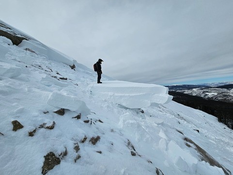
Avalanche conditions are changing fast. This slide caught CAIC forecasters off guard earlier this week — before the huge storm that’s about to hit. While doing fieldwork on Vail Pass, they unintentionally triggered this large (D2) Persistent Slab avalanche on a 27-degree, wind-drifted, north-facing slope. The incoming storm will increase the avalanche danger to HIGH (4 of 5) in many places across the state.
The Colorado Avalanche Information Center (CAIC) is warning backcountry travelers that the avalanche danger will rise to HIGH (4 of 5) over the Valentine’s Day and Presidents Day weekend, one of the busiest—and, historically, most dangerous—times of the season.
“We want people to enjoy a holiday weekend in the mountains, but they need to make sure their plan matches the avalanche danger, which will be higher than it has been in a month and a half,” said CAIC Director Ethan Greene.
A powerful storm is set to arrive Thursday night, bringing heavy snowfall and strong winds to the mountains through Saturday.
“Starting Friday, the avalanche danger will be HIGH in a lot of our mountains west of the Continental Divide,” said Greene. “We’re particularly concerned about avalanche accidents this weekend because portions of our snowpack are quite weak. We’ll see heavy snowfall after a fairly dry period, and lots of people will be heading into the backcountry to enjoy the holiday weekend.”
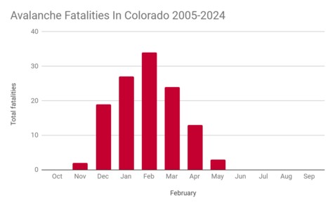
February is the deadliest month for avalanches in Colorado, and Valentine’s Day through Presidents Day weekend is the most dangerous period of the season. Over the past 10 years, eight people have died in avalanches between February 14-16.
“We expect natural avalanches this weekend, and people venturing into the backcountry will be able to trigger slides big enough to bury, injure, or kill them,” Greene warned. “And once the skies clear on Sunday, the chances of an accident will increase due to the nice weather, new snow, and dangerous avalanche conditions.”
CAIC assigns avalanche danger ratings using the North American Public Avalanche Danger Scale, ranging from LOW (Level 1) to EXTREME (Level 5). When conditions become particularly hazardous, CAIC issues Avalanche Watches and Warnings to alert the public. Additionally, Special Avalanche Advisories are released when a significant safety risk coincides with a high-traffic period, such as a major storm during a holiday weekend.
Backcountry travelers should take the following precautions:
Avoid avalanche-prone terrain during periods of heightened danger.
Always carry proper avalanche safety gear, including a transceiver, probe, and shovel — and know how to use them.
February is historically the deadliest month for avalanches in Colorado, with the highest concentration of fatalities occurring between February 13-16. Over the past 20 years, more than one-third of all February avalanche deaths have happened during this four-day period — nearly double the expected number if fatalities were evenly distributed throughout the month.
Garfield County Emergency Communications Authority
11:19.24, 8 a.m. – Road open: I-70 is open between mile markers 116-131 eastbound, Glenwood Springs to Dotsero.
11.19.24, 7:04 a.m. – Road closed: I-70 is closed between mile markers 116 eastbound Glenwood Springs to mile marker 131 eastbound Dotsero, due to an accident.
11.6.24, 12:44 p.m. – Police activity on the Roaring Fork River bike path near 8th street. Please avoid the area. Follow Glenwood Police Department on Facebook at cogs.us/police. For emergencies, dial 911.
***
Actividad policial en el sendero para bicicletas Roaring Fork cerca de la calle 8. Por favor, evite la zona.
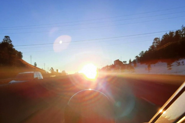
Travel alert – Sun glare safety closures on eastbound I-70 at Floyd Hill begin in November Motorists should expect delays in the early morning hours on sunny days I-70 Mountain Corridor — Sun glare season is here and that means on sunny mornings, eastbound Interstate 70 at Floyd Hill east of Idaho Springs will close from sunrise to 8:30 a.m. from early November through February. When closures occur, drivers traveling on eastbound I-70 should prepare for delays of up to an hour. The first closure could occur at sunrise on Sunday, Nov. 3 if the weather is clear and sunny.
The Colorado Department of Transportation (CDOT) and the Colorado State Patrol (CSP) want to remind drivers that the closures are necessary to prevent crashes because the sun glare on eastbound I-70 is blinding. The sun’s angle, in combination with the hill and the highway’s configuration, can create a blinding sun glare for drivers as they head eastbound up Floyd Hill (about Mile Points 244 to 248 – east of Idaho Springs). The intense sun glare occurs as far east as Genesee beginning around sunrise and lasting until around 8:30 a.m.
Detour route
If a sun glare safety closure is in place along eastbound I-70:
Traffic headed eastbound on I-70 will be rerouted at Exit 244 (US 6) which is at the bottom of Floyd Hill.
Motorists can either stay the course on US 6 through Clear Creek Canyon, or they can take the eastbound I-70 frontage road (US 40) and get back onto I-70 at Beaver Brook (Exit 248).
Truckers should be aware, there are height restrictions in the tunnels along US 6 Clear Creek Canyon, no vehicles over 12′ 7″ can travel this route.
The closures average around 45 minutes to an hour and can occur between sunrise and 8:30 a.m. from November through February each year.
Drivers who travel eastbound I-70 in the early morning hours during fall and winter are urged to pay attention to the overhead message boards beginning just east of the Eisenhower Johnson Memorial Tunnel. The signs will have the latest information on sun glare closures. Drivers can also check the travel alerts by going to COtrip.org.
The sun glare closures at Floyd Hill are for the safety of the traveling public. The decision is made on a case by case basis each morning with collaboration between CSP and CDOT personnel who are stationed near Floyd Hill. The eastbound sun glare can become blinding for drivers, especially when there is leftover moisture on the roadway from a storm or from pre-storm road treatment materials. On top of that, mountain driving conditions include steep hills, sharp turns, and possibly wildlife crossing the highway. For these reasons, the sun glare safety closures at Floyd Hill become necessary. This is a unified effort between CSP and CDOT to keep motorists as safe as possible.
Other driver recommendations
Adjust your eastbound I-70 travel plans near Floyd Hill to before sunrise or later in the morning. Prepare for a sun glare safety closure to occur if you are traveling eastbound up Floyd Hill between 7 a.m. and 8:30 a.m. on sunny days November through February.
Make sure your windshield is clean – inside and out. Ensure your vehicle has plenty of windshield wiper fluid.
Wear a good pair of sunglasses to provide shading.
Expect traffic slowdowns between 6:30 and 8:30 a.m. along I-70 eastbound near Floyd Hill, and adjust your speed to avoid sudden reactions.
Let off the accelerator and slow down gradually instead of slamming on the brakes, if suddenly blinded by the sun.
Road conditions can change quickly at this time of year. Drivers can check the latest road and weather conditions by going to COtrip.org.
October 28, 2024, 3:22 p.m.: Update: The gas line has been secured. All evacuation and shelter-in-place orders have been lifted. Crews will continue working in the area, so please avoid 6th Street between Maple and Olive.
ACTUALIZACIÓN 3:22 p.m.: La línea de gas ha sido asegurada. Todas las órdenes de evacuación y de refugio en el lugar han sido levantadas. Las cuadrillas continuarán trabajando en el área, por lo que se recomienda evitar la calle 6, entre Maple y Olive.
October 28, 2024, 2:36 p.m.: – Our team is responding to a ruptured gas line near 6th Street and Pine Street. Black Hills Energy is also on scene and actively working to control the leak. For public safety, the area east of Maple Street is under a combination of Shelter in Place and Evacuation Orders. This includes the Hot Springs Pool, Hotel Colorado, and Yampah Vapor Caves.
We advise all residents and businesses to follow instructions from emergency personnel on site. Please avoid the area to ensure the safety of all responders and residents.
Further updates will be provided as the situation evolves.
Nuestro equipo está respondiendo a una ruptura de línea de gas cerca de la Calle 6 y la Calle Pine. Black Hills Energy también está en el lugar y trabajando activamente para controlar la fuga. Para la seguridad pública, el área al este de la Calle Maple está bajo una combinación de órdenes de Refugiarse en el Lugar y de Evacuación. Esto incluye las instalaciones de Hot Springs Pool, Hotel Colorado y Yampah Vapor Caves.
Aconsejamos a todos los residentes y negocios seguir las instrucciones del personal de emergencia en el sitio. Por favor, eviten la zona para garantizar la seguridad de todos los respondientes y residentes.
Se proporcionarán más actualizaciones a medida que evolucione la situación.