Garfield County Emergency Communications Authority
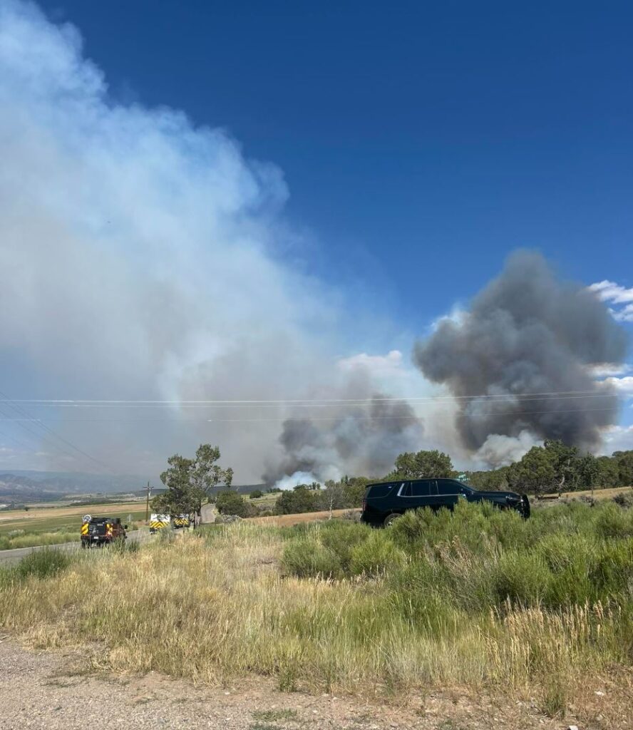
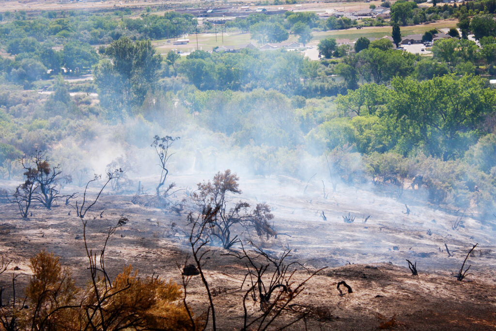
This incident has been named the Hilltop Fire.
June 26, 2025, 3:35 p.m. – PRE-EVACUATION: Residents over one mile, but within two miles of county road 320/county road 309: Due to a Fire, please prepare for possible evacuation orders issued by Garfield County Sheriff’s Office. You will receive another message if evacuations are ordered.
June 26, 2025, 3:26 p.m. – EVACUATION: If you are EAST of the fire, EVACUATE to the FAIRGROUNDS in Rifle, if you are WEST of the fire EVACUATE to COTTONWOOD PARK/PARACHUTE FAIRGROUNDS.
June 26, 2025, 3:06 p.m. – EVACUATION: County Road 320 (Rifle-Rulison Road) and County Road 309 (Rulison-Parachute Road: Due to fire, EVACUATE the area immediately.
GarCo911: Incendio en County Road 320/CR 309: EVACUAR el área inmediatamente
26 de junio de 2025, 15:35 – AVISO DE PREEVACUACION: a más de una milla, pero a menos de dos millas de la carretera del condado 320/carretera del condado 309: Debido a un incendio, por favor, prepárense para posibles órdenes de evacuación emitidas por la Oficina del Sheriff del Condado de Garfield. Recibirán otro mensaje si se ordena la evacuación.
26 de junio de 2025, 15:26 – EVACUACION: Carretera del Condado 320/Carretera del Condado 309: Debido al incendio, evacue la zona inmediatamente. Si se encuentra al ESTE del incendio, evacue al RECINTO FERIAL de Rifle; si se encuentra al OESTE del incendio, evacue al PARQUE COTTONWOOD/RECINTO FERIAL DE PARACAIDISTAS.
26 de junio de 2025, 15:06 – EVACUACION: County Road 320 (Rifle-Rulison Road) y County Road 309 (Rulison-Parachute Road): debido al incendio, evacue el área inmediatamente.
Garfield County Sheriff’s Office
June 26, 2025, 3:38 p.m. – Brush Fire at County Road 309 (Rulison area), moving East and South. Pre-evacuation starting at County Road 329. Evacuations in place 1 mile West and East from Intersection of County Road 309 & 320. If you are on the West side you may evacuate to Parachute Fairgrounds on the East side to Garfield County Fairgrounds.
26 de junio de 2025, 15:38 – Incendio forestal en la carretera del condado 309 (zona de Rulison), avanzando al este y al sur. Se inicia la preevacuación en la carretera del condado 329. Se han establecido evacuaciones a 1.6 km al oeste y al este de la intersección de las carreteras del condado 309 y 320. Si se encuentra en el lado oeste, puede evacuar al recinto ferial Parachute, ubicado en el lado oeste, al recinto ferial del condado de Garfield.
Holy Cross Energy
June 26, 2025, 3:28 p.m. – Power is out in the Rulison to Parachute area due to fast-moving wildfire activity. Please avoid the area and take all necessary safety precautions.
26 de junio de 2025, 15:28 – Se ha producido un corte de electricidad en la zona de Rulison a Parachute debido a la rápida actividad de los incendios forestales. Evite la zona y tome todas las precauciones de seguridad necesarias.
Garfield County, the Garfield County Sheriff’s Office, Bureau of Land Management (BLM), the U.S. Forest Service, and the seven fire districts in Garfield County are implementing Stage 1 fire restrictions effective at midnight on Thursday, June 26, 2025. This applies to all of Garfield County.
This decision was made with thoughtful consideration. We look at the data, the potential for significant wildfires, and balance it with the impacts to our community. Our concern, with the level of fire danger we are seeing; one spark could quickly spread into a dangerous wildfire threatening lives, property, and natural resources.
Fire restrictions are implemented based on specific criteria, including moisture content of vegetation, weather outlooks, human risk factors, and firefighting resource availability. It has been hot, dry, and unseasonably windy. So far this year, we have had several Red Flag warnings. The National Weather Service is forecasting above average temperatures and dry conditions with no relief from rain anytime soon.
With increasingly dry vegetation, severe drought conditions, and more hot and dry conditions approaching, the danger for human-caused wildfires increases even more.
What Stage I fire restrictions mean in Garfield CountyFireworks are not allowed under Stage I Fire Restrictions. Professional fireworks shows may be allowed through the permitting process.All burn permits are postponed/Canceled until further notice.Campfires are only allowed within designated fire grates in developed areas (i.e. a permanent in-ground containment structure or store bought fire pit) A temporary fire pan and rock campfire rings will not be acceptable.No fires of any type including charcoal in undeveloped areas.No smoking except within a designated area, enclosed vehicle or building, a developed area or in an area free of combustibles.No use of fireworks or explosive materials, including “exploding” targets or bullets and tracer rounds.Exercise common sense and industry safety practice when welding or operation of an acetylene or other similar torch with open flame always cleared safe area of vegetation and combustibles.
Penalties Causing a fire during fire restrictions can be a class 6 felony and can be punishable by fines. Other possible charges range from a Class 2 felony to a petty offense depending on the value of the damage caused. You may be held financially responsible for damage caused.
Federal lands The use of fireworks, flares, or other incendiary devices, including exploding targets, are always prohibited on Federal lands.
By definition: A “developed area” is an area, whether within city limits or rural, that is groomed, manicured and or watered, where grasses, brush and trees are regularly attended to by landowner. This includes residential and business areas, improved recreational areas, parks and other common areas.
An “undeveloped area” are lands that are not groomed, manicured, or watered, where grasses, brush and trees have been allowed to grow in a natural environment. This includes green belts that are not landscaped or manicured, open space lands, non-manicured park lands, and other areas where the fire hazard presented by the vegetation is determined by the authority having jurisdiction or designee to be an undue wildland fire hazard.
U.S. Forest Service and the Bureau of Land Management
White River National Forest and BLM Upper Colorado River District to enact stage 1 fire restrictions
June 25, 2025, 1:04 p.m. – GRAND JUNCTION, Colo. – All lands managed by the White River National Forest and the Bureau of Land Management Upper Colorado River District will be under stage 1 fire restrictions beginning Friday, June 27.
Under stage 1 restrictions for the Bureau of Land Management and White River National Forest:
campfires are only allowed within designated fire grates in developed campgrounds (including the Forest Service Homestake Valley designated dispersed camping sites in Eagle County); this means a metal, in-ground containment structure — fire pans and rock campfire rings are not acceptable.
no fires of any type including charcoal outside of developed areas
no smoking except within an enclosed vehicle or building, a developed recreation site or in a barren area free of vegetation
no use of explosive materials, including explosive targets
no welding or operation of an acetylene or other similar torch with open flame except from an area that has been cleared of vegetation
no operation of any internal combustion engine without a spark arresting device properly installed and in working order
Although conditions vary across the area, a longer-term drying trend is expected to continue.
“Fire restrictions are prudent at this time considering the long-range forecast, fuel moisture conditions on the ground, and the continued high public visitation,” said White River National Forest Supervisor Brian Glaspell. “In developed campgrounds where campfires are permitted, please ensure your fire is completely out and cold before leaving.”
“As we enter stage 1 fire restrictions, it’s crucial for everyone to understand the importance of fire safety during this dry season,” said BLM Upper Colorado River District Manager Greg Larson. “We urge all residents and visitors to be vigilant and responsible with any outdoor activities that could spark a fire. Remember, fireworks are not allowed on federal land.”
Officials consider several criteria when determining the need for fire restrictions, including current and anticipated fire danger, resource availability, and consistency with neighboring jurisdictions. Local, county, state and federal officials within this area evaluate and coordinate fire restrictions weekly during fire season.
BLM Grand Junction and Colorado River Valley Field Offices, part of the BLM Upper Colorado River District, and unincorporated private lands in Eagle, Garfield, Mesa, Pitkin and Summit counties will also enter fire restrictions this week.
June 23, 2025, 4:26 p.m. – Garfield County has passed an ordinance prohibiting the use, sale, and possession of fireworks in unincorporated areas. Garfield County Emergency Manager Chris Bornholdt told the Board of County Commissioners that local conditions and future predictions indicate an extreme fire danger in the area. The ordinance notes that sagebrush fuel moisture “is at or below 100 percent, a near record low.
Measurements taken in the county indicate Pinyon pine and juniper fuel moisture is 72 percent (significantly below normal moisture content percentages). Fuel moisture percentages are expected to further decrease in the next two weeks, creating high fire danger.”
Flammable shrubs will “burn aggressively” if live moisture content is between 100 and less than 80 percent, according to the National Wildfire Coordinating Group (NWCG).
The National Oceanic and Atmospheric Administration (NOAA) is projecting no significant rain the 14 days following June 23, 2025. NOAA’s Climate Prediction Center is anticipating above average temperatures from now through August in the region, and the U.S. Department of Agriculture’s drought monitor classifies the majority of Garfield County in “severe drought.”
The board assessed the evidence and found that high fire danger exists, supporting the fireworks prohibition. A state law exempts firework prohibitions between the dates of May 31 through July 5, unless counties show “competent evidence of high fire danger.”
Anyone using fireworks in violation of the ordinance is subject to a fine of up to $1,000 for each separate violation.
The ordinance covers unincorporated Garfield County; municipalities make their own rules regarding whether fireworks are prohibited. On federal lands, including Bureau of Land Management (BLM) and U.S. Forest Service lands, the use of fireworks, flares, or other incendiary devices, including exploding targets, is always prohibited.
The board unanimously approved the ordinance, 3-0, which is in effect immediately and remains so for one year.
June 23, 2025, 3:34 p.m. – We are responding to a brush fire in the West Glenwood Area. Donegan Road has been closed in both directions between Vista Drive and Sunny Acres Road. Please avoid this area for emergency responders.
Garfield County Emergency Communications Authority
June 23, 2025, 3:58 p.m. – Sunny Acres residents: Pre-evacuation has been lifted by the Glenwood Springs Police Department. The fire is contained.
June 23, 2025, 3:34 p.m. – Sunny Acres residents: Due to a fire, please prepare for possible evacuation orders issued by the Glenwood Springs Police Department. You will receive another message if evacuations are ordered.
Se ha levantado la evacuación previa
23 de junio de 2025, 15:58 – Residentes de Sunny Acres: El Departamento de Policía de Glenwood Springs ha levantado la orden de evacuación. El incendio está contenido.
23 de junio de 2025, 15:34 – Residentes de Sunny Acres: Debido a un incendio, les pedimos que se preparen para posibles órdenes de evacuación emitidas por el Departamento de Policía de Glenwood Springs. Recibirán otro mensaje si se ordena la evacuación.
June 20, 2:25 p.m. – There is an Xcel electric transmission outage affecting parts of Glenwood Springs and other parts of the valley. Xcel crews are aware and are working on bringing the system up as quickly as possible. There is no estimate at this time for power to be restored. Updates will be posted at cogs.us.
On June 18, 2025, the SPEAR task force, with the assistance of the Garfield County All Hazards Response Team (AHRT), executed a narcotics related search warrant at 513 West Ave. in the City of Rifle.
With elements of this case still open, we will hold off on some of the details but wanted the public to know there is no ongoing threat to the community.
SPEAR would like to thank the Garfield County Sheriff’s Office and the Rifle Police Department for their assistance.
SPEAR is a multi-jurisdictional task force based out of the Garfield County, comprised of local and federal law enforcement agencies. Anyone with information on criminal activity is encouraged to reach out to SPEAR through your local law enforcement agency or dispatch at 970 625-8095.
June 9, 2025, 3:23 p.m. – A power outage is planned for the Town of Parachute on June 10, 2025, from roughly 7 p.m. until June 11, 2025, at 6 a.m. The outage is needed while Xcel Energy replaces several utility poles and makes repairs as part of its wildfire mitigation program (WMP). Xcel has placed calls to affected homeowners and notified the town of the outage.
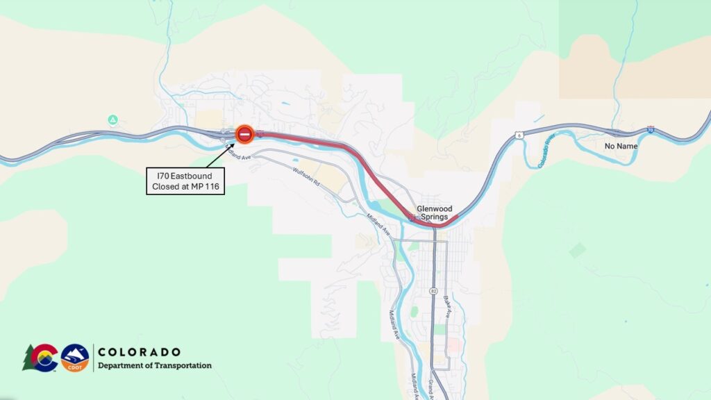
April 24, 2025, 10:10 a.m. – Interstate 70 eastbound lanes are closed near Glenwood Springs with detours in place for commuters. It is not known when the interstate will open for eastbound travelers. At approximately 8 a.m. a commercial vehicle hauling cattle crashed onto its side and blocked both eastbound lanes of traffic near Mile Point 116, just west of the Grand Avenue exit. For local traffic, I-70 eastbound remains open up to Exit 114, West Glenwood. Colorado Department of Transportation, Glenwood Springs Police, and other first responder agencies are on the scene.
Commuters are urged to proceed with caution along the detour routes listed below.
Northern alternate route
To use the northern alternate route, eastbound commuters will take Colorado Highway 13 in Rifle north to Craig. In Craig, turn east on US highway 40 to Steamboat Springs. Just outside of Steamboat Springs, take either CO 131 south and back on to I70 or US 40 and continue east.
Southern alternate route
To use the southern alternate route, eastbound motorists from the Grand Junction area can travel on US 50 US 285 through Gunnison, and continue to Denver and areas nearby. Note: Cottonwood Pass on CO 306 is still closed for the season and not a viable alternative route.
Glenwood Springs Police Department
April 24, 2025, 9:31 a.m. – Glenwood Springs Police Department: Exit 114 is open. Exit 116, all lanes remain closed due to an accident involving a semi carrying cattle. No estimated time of reopening. Detour in place north via Rifle CO-13 to Craig US-40 & South Clifton/Montrose US-50 to Leadville US-24.
Garfield County Emergency Communications Authority
April 24, 2025, 2:13 p.m. – Eastbound I-70 is open at Glenwood Springs.
April 24, 2025, 9:40 a.m. – Eastbound Interstate 70 remains closed at mile marker 114, West Glenwood exit, and has moved back to eastbound mile marker 116, the main Glenwood Springs exit.
April 24, 2025, 8:08 a.m. – Eastbound Interstate 70 is closed at mile marker 114, West Glenwood exit, due to an accident.