Garfield County Emergency Communications Authority
4.4.25, 6:09 am: I-70 is open at 116 eastbound, main Glenwood Springs exit.
Colorado Department of Transportation
4.3.25, 11:13 pm: Between Exit 114: West Glenwood (Glenwood Springs) and Exit 129: Bair Ranch (6 miles west of Dotsero) from Mile Point 116 to Mile Point 126.5. Road closed – expect delays due to a rock slide.
Comment: This will be an extended closure.
4.3.25, 10:25 pm: Between Exit 114: West Glenwood (Glenwood Springs) and Exit 129: Bair Ranch (6 miles west of Dotsero) from Mile Point 116 to Mile Point 126.5. Road closed – expect delays due to a rock slide. CDOT will post updates at cotrip.org.
Garfield County Emergency Communications Authority
4.3.25, 10:10 pm: I-70 is closed at mile marker 116 eastbound, Glenwood Springs, due to a rock slide in Glenwood Canyon.
Garfield County Emergency Communications Authority
4.4.25, 6:09 am: I-70 is open at 116 eastbound, main Glenwood Springs exit.
Colorado Department of Transportation
4.3.25, 11:13 pm: Between Exit 114: West Glenwood (Glenwood Springs) and Exit 129: Bair Ranch (6 miles west of Dotsero) from Mile Point 116 to Mile Point 126.5. Road closed – expect delays due to a rock slide.
Comment: This will be an extended closure.
4.3.25, 10:25 pm: Between Exit 114: West Glenwood (Glenwood Springs) and Exit 129: Bair Ranch (6 miles west of Dotsero) from Mile Point 116 to Mile Point 126.5. Road closed – expect delays due to a rock slide. CDOT posts all updates at cotrip.org.
Garfield County Emergency Communications Authority
4.3.25, 10:10 pm: I-70 is closed at mile marker 116 eastbound, Glenwood Springs, due to a rock slide in Glenwood Canyon.
Winter travel alert: Treacherous conditions remain on I-70 mountain corridor for Presidents’ Day traffic – CDOT maintenance teams perform critical winter safety operations beginning at 9 a.m. Tuesday, Vail Pass to close for lengthy delay
12.17.25 Eagle County — Travelers on Interstate 70 are urged to be prepared for continued severe weather and treacherous driving conditions today. Motorists will encounter slick, ice and snow-packed roads. Additionally, heavy snows and strong winds will bring low visibility and potential whiteout conditions at times.
The severe weather and roadway conditions have caused numerous closures. Some closures have been implemented for safety, but several closures have been the result of vehicle spin-outs, slide-offs, and crashes.
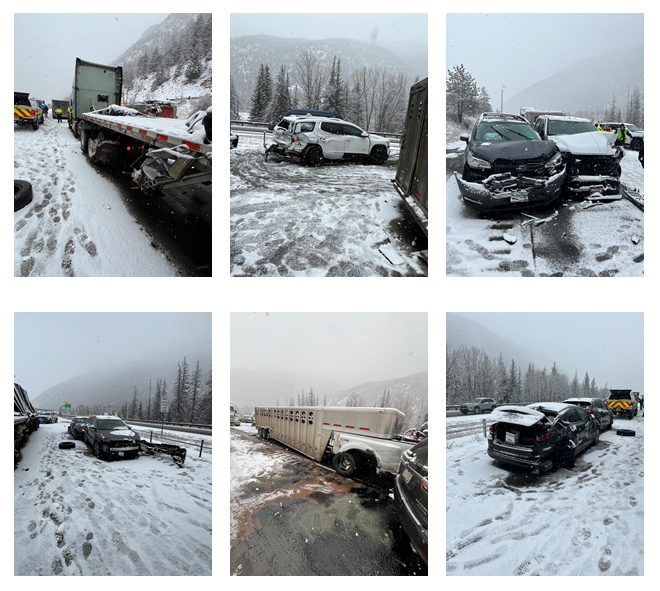
CDOT photos above: Crash images captured from Monday’s I-70 westbound closure near Empire Junction/ Exit 232 and Georgetown/ Exit 228.
Natural avalanches have also been visible in the mountains today. While a video captured earlier today by the Colorado Avalanche Information Center (CAIC) showed an avalanche that did not reach the roadway of I-70 through Ten Mile Canyon, the danger of additional slides remains high. In addition, CDOT and CAIC teams saw results of slide control work on Berthoud Pass early this morning, after avalanche mitigation debris did reach the roadway. US 40 required clean-up and re-opened safely to vehicles.
Visitors to the high country who plan to return to the Front Range should prepare for a difficult trip. Travelers should keep extra food, water, and warm clothing readily available and be prepared for lengthy delays in severe weather conditions. COtrip.org will continue to show current road and weather conditions, as well as any road closures. Even so, the extreme weather conditions may cause additional incidents on the road as people try to return from the mountains while the storm continues to deliver heavy snowfall and high winds.
I-70 Vail Pass closure Tuesday morning
The Colorado Department of Transportation will perform winter maintenance operations on Interstate 70 Vail Pass tomorrow, Tuesday, February 18. Operations will begin at 9 a.m., and motorists can expect a lengthy delay lasting for much of the morning. There is not an exact time estimated for opening, as operations are dependent upon weather conditions and the amount of snow crews must clear from the roadway.
Traffic impacts and closure points
• Eastbound travelers will be stopped three miles east of Vail at exit 180. This closure point allows motorists to switch travel directions and turn westbound back toward Vail • Eastbound commercial traffic is urged to stop and wait at the Dotsero commercial motor vehicle parking lot, exit 133 • Westbound travelers will be stopped at exit 195 near Copper Mountain Motorists should plan ahead, allow for extra travel time, or arrive and drive through the closure points before the designated closure time of 9 a.m.
Visit COtrip.org for the latest information on road closures and conditions.
Colorado Avalanche Information Center and National Weather Service
SPECIAL AVALANCHE ADVISORY
BULLETIN – IMMEDIATE BROADCAST REQUESTED
COLORADO AVALANCHE INFORMATION CENTER
RELAYED BY NATIONAL WEATHER SERVICE DENVER/BOULDER CO
436 PM MST SAT FEB 15 2025
THE FOLLOWING MESSAGE IS TRANSMITTED AT THE REQUEST OF THE COLORADO AVALANCHE INFORMATION CENTER.
…A SPECIAL AVALANCHE ADVISORY IN EFFECT FROM 4:30 PM SATURDAY UNTIL 5 PM MONDAY…
*WHAT…Heavy snow and strong winds dramatically changed avalanche conditions. You can easily trigger large, deadly avalanches throughout Presidents Day weekend.
*WHERE…Flat Top Mountains…Medicine Bow Mountains…Never Summer Mountains…Front Range…Williams Fork Mountains…Never Summer Mountains…Gore and Elk Mountains…Ten Mile Range…Ruby Range…West Elk Mountains…Sawatch Range…San Juan Mountains…San Miguel Mountains…Rico Mountains…Grand Mesa
*WHEN… The Special Avalanche Advisory goes from Saturday at 4:30 PM till Monday at 5 PM.
*IMPACTS… Easily trigger dangerous avalanches large enough to injure or kill you.
*PRECAUTION/PREPAREDNESS ACTIONS… Travel in backcountry avalanche terrain requires cautious route finding to stay safe. Avoid travel on and under slopes with a slope angle steeper than about 30 degrees. You can find more detailed information at colorado.gov/avalanche.
Garfield County Emergency Communications Authority
11:19.24, 8 a.m. – Road open: I-70 is open between mile markers 116-131 eastbound, Glenwood Springs to Dotsero.
11.19.24, 7:04 a.m. – Road closed: I-70 is closed between mile markers 116 eastbound Glenwood Springs to mile marker 131 eastbound Dotsero, due to an accident.