Garco911: I-70 westbound closures for mud slides

Colorado Department of Transportation

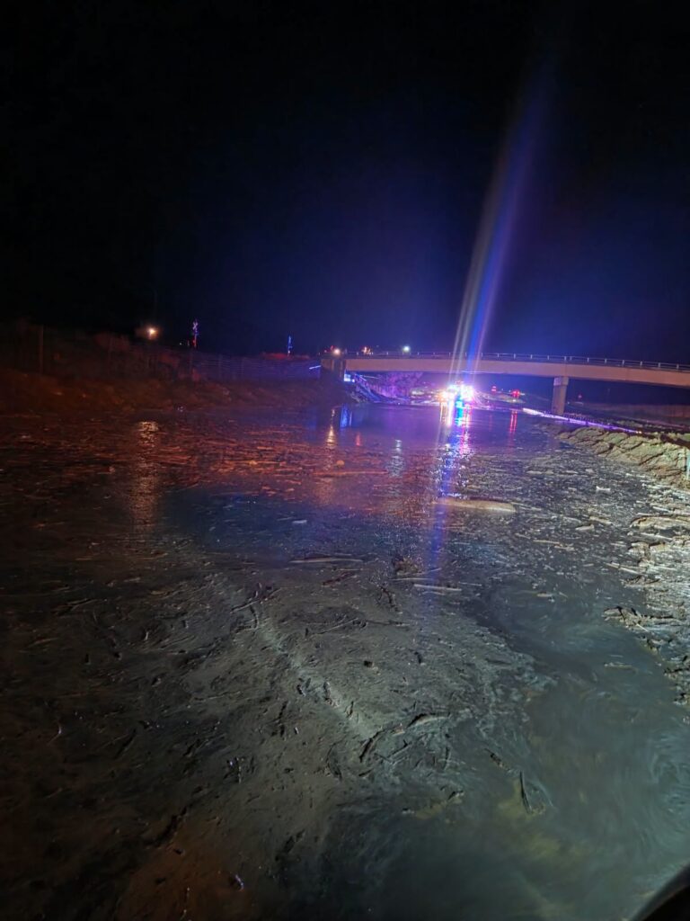
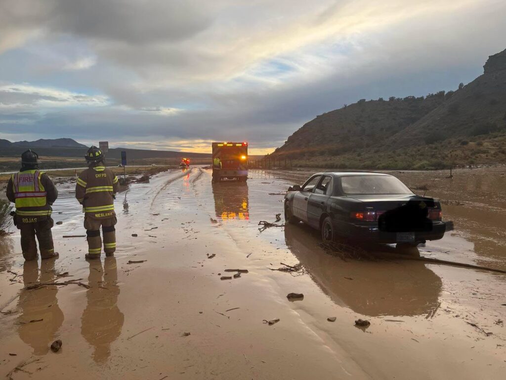
Westbound I-70 is CLOSED between New Castle and Silt – 9:00 p.m. (8/30/2026) – I-70 westbound lanes are closed from New Castle, mile point 101, due to mudslide and flooding.

Commuters can expect detours onto US 6 and the frontage road. There is no estimated time for reopening.

Check the latest road conditions on COtrip.org or on the #COtrip Planner app

Garfield County Emergency Communications Authority

8.30.26, 8:24 pm – I-70 is closed at mile marker 105 westbound, New Castle, due to a mud slide. Traffic is being diverted onto Highway 6.

8.30.26, 7:38 pm – I-70 is also closed at mile marker 75 westbound, Parachute, due to a mud slide. Traffic is being diverted onto Highway 6

8.30.26, 7:12 pm – I-70 is closed at mile marker 72 westbound, West Parachute, due to a mud slide. Traffic is being diverted onto Highway 6.

Mud and debris on Interstate 70

GARFIELD COUNTY EMERGENCY COMMUNICATIONS AUTHORITY
REGISTER for alerts – garco911.com | Reachwell mobile app

Garco911: I-70 westbound closures for mud slides

Garco911: County Road 311 south of Silt reopened

Garfield County Emergency Communications Authority

8.29.26, 7:23 p.m. County Road 311 is open at the intersection of County Road 331 and County Road 311 eastbound, south of Silt.

8.29.26, 6:40 p.m. – County Road 311 is closed at the intersection of County Road 331 and County road 311 eastbound, south of Silt, due to a fire.

GARFIELD COUNTY EMERGENCY COMMUNICATIONS AUTHORITY
REGISTER for alerts – garco911.com | Reachwell mobile app

Garco911: County Road 311 south of Silt reopened

Garco911: I-70 eastbound reopened at New Castle

Garfield County Emergency Communications Authority

8.28.26, 8:31 a.m. – I-70 is open at mile-marker 105 EB, New Castle.

8.28.26, 7:54 a.m. – I-70 is closed at mile marker 105 eastbound, New Castle, due to an accident.

GARFIELD COUNTY EMERGENCY COMMUNICATIONS AUTHORITY
REGISTER for alerts – garco911.com | Reachwell mobile app

Garco911: I-70 eastbound reopened at New Castle

Garco911: I-70 reopened between South Canyon and Canyon Creek

Garfield County Emergency Communications Authority

8.23.26, 2:29 p.m. – I-70 is open between mile markers 111 to the 109 westbound, South Canyon to Canyon Creek.

8.23.26, 1:23 p.m. – I-70 is closed between mile markers 111 to the 109 westbound, South Canyon to Canyon Creek, west of Glenwood Springs, due to an accident.

Garco911: I-70 reopened between South Canyon and Canyon Creek

USFS: Firefighters contained Elk Knob Fire on Flat Tops

White River National Forest

Aug. 21, 2026 7 p.m. – Today firefighters brought the 6-acre Elk Knob Fire in the Flat Tops Wilderness to 100 percent containment. A heavy helicopter provided some last water drops, and a medium helicopter gave the 10 firefighters working the fire a ride off the mountain this afternoon.

Aug. 20, 7:30 p.m. Firefighters made good progress on the Elk Knob fire today despite hot, dry conditions.

The 6-acre Elk Fire in the Flat Tops Wilderness is now 80 percent contained. Firefighters will continue mopping up and securing fireline tomorrow.

Updates on both fires will continue to be posted on the U.S. Forest Service – White River National Forest Facebook page.

Aug. 18, 8:30 p.m. – Nineteen firefighters worked the Elk Knob Fire in a remote part of the Flat Tops Wilderness in Garfield County (about seven miles due north of Heart Lake). They were supported by two helicopters dropping water.

Firefighters include two engine crews who hiked in several miles from the end of the Coffee Pot Road, four rappellers who rappelled from a helicopter, and six smokejumpers who parachuted in. The fire is currently estimated at 1-2 acres. An additional 10 firefighters will join the effort today.

The fire is likely a lightning holdover from several days ago. It is not uncommon for lightning fires to take several days to put up enough smoke to be detected, especially when an area receives rain with the lightning.

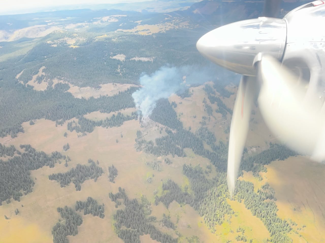
Elk Knob Fire in Flat Tops shows smoke plume in aircraft image

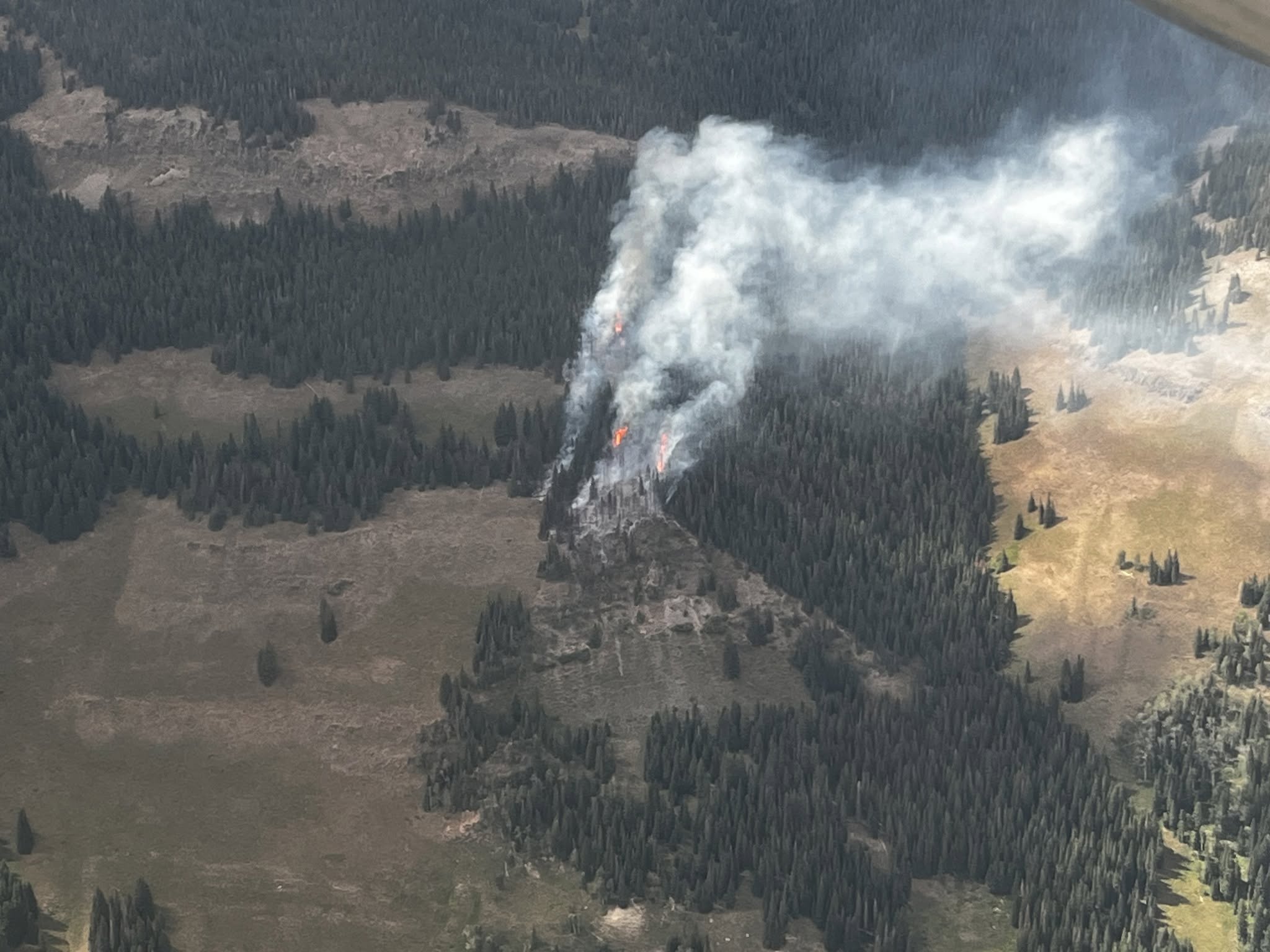
Elk Knob Fire in Flat Tops shows flames in trees and smoke plume

WHITE RIVER NATIONAL FOREST
White River National Forest | facebook @WhiteRiverNF facebook | Inciweb wildfire

USFS: Firefighters contained Elk Knob Fire on Flat Tops

GCSO: 310 Fire evacuations lifted

Garfield County Sheriff’s Office

8.13.26, 12:30 p.m. – The Garfield County Sheriff’s Office has lifted all evacuation statuses for the 310 Fire near Battlement Mesa and Parachute. Overnight moisture assisted in reduction of risk for remaining READY status areas. All roadblocks in the incident area have been removed.

The Garfield County Sheriff’s Office thanks the community in the affected area for acting quickly to accommodate evacuations.

Also, we thank Grand Valley Fire Protection District for initial attack on the fire, Parachute Police Department, Colorado Incident Management Team for ongoing suppression activity, Upper Colorado River Interagency Fire Management, mutual aid fire agencies and all agencies contributing to the continued suppression and increased containment for this fire.

Stage 2 Fire Restrictions remain in effect throughout Garfield County and on land managed by the Bureau of Land Management and the White River National Forest.

Please visit Garfield County Emergency Management’s evacuation preparation page | planificación de evacuaciones and follow READY | SET | GO guidance to prepare yourself, your family and your home for future incidents.

GCSO: 310 Fire evacuations lifted

310 Fire update – August 13

Thursday, August 13, 2026 – 8:00 a.m.
Colorado Incident Management Team
Phil Daniels, Incident Commander

Size: 603 acres | Containment: 90% | Total Personnel: 125
Location: 3.5 miles southeast of Parachute, CO in Garfield County
Reported: August 6, 2026, at 12:37 p.m.

Current Situation: This will be the last daily update from Team Colorado, as the team will transfer command of the fire back to a Type 4 Incident Commander on Friday morning. Crews are creating depth along containment lines to increase confidence. In the southeast corner, firefighters are actively using the remaining hose lays to increase moisture and raise humidity under the dense oak canopy. Crews will continue to use sprinklers to saturate the understory further into the interior.

Weather: Today will be partly sunny with a slight chance of showers in the morning and a higher chance of wetting rains and thunderstorms after noon and into the evening. Light and variable winds throughout the day will increase as thunderstorms roll in.

Fire Behavior: Overnight storms increased moisture on the fire and raised humidity to 30%. The southeast corner of the fire continues to hold heat; however, with the increased rain and low winds in the forecast, fire behavior is expected to be minimal.

Fire Restrictions: Stage 2 Fire Restrictions remain in effect throughout Garfield County and on land managed by the Bureau of Land Management and the White River National Forest. All open fires are prohibited to help reduce the risk of wildfire ignition and spread.
Evacuations/Closures: For the most updated information, please visit the Garfield County Emergency Operations Center page at garfieldcounty.net. Register for emergency alerts at garco911.com.

For updates, visit the Grand Valley Fire Protection District Facebook page.

GRAND VALLEY FIRE PROTECTION DISTRICT
Grand Valley Fire website | facebook @Grand Valley Fire Protection District

310 Fire update – August 13

310 Fire update – August 12

Wednesday, August 12, 2026 – 8:00 a.m.
Colorado Incident Management Team
Phil Daniels, Incident Commander

Size: 603 acres | Containment: 76% | Total Personnel: 163
Location: 3.5 miles southeast of Parachute, CO, in Garfield County
Reported: August 6, 2026, at 12:37 p.m.

Current Situation: Firefighters continue to make progress, increasing containment around the fire. On the eastern edge of the fire, crews are working to open space in dense oak stands to reduce fuels and strengthen containment lines. Crews continue to mop up around the perimeter of the fire. Several crews will focus on extinguishing heat along the southern edge where most of the heat remains. Backhauling operations continue as equipment is no longer needed.

Weather: Today’s forecast calls for high cloud coverage, which will lower temperatures and raise humidity. There is a low chance of rain, but increased potential for afternoon thunderstorms throughout the week and into the weekend.

Fire Behavior: Increased humidity and low winds will help moderate fire behavior. The head of the fire continues to smolder in interior pockets of unburned fuels, as well as along the edges where crews continue to mop up and secure the line.

Fire Restrictions: Stage 2 Fire Restrictions remain in effect throughout Garfield County, and on land managed by the Bureau of Land Management and the White River National Forest. All open fires are prohibited to help reduce the risk of wildfire ignition and spread.

Evacuations/Closures: For the most updated information, please visit the Garfield County Emergency Operations Center page at garfieldcounty.net. Register for emergency alerts at garco911.com.

For updates, visit the Grand Valley Fire Protection District Facebook page.

GRAND VALLEY FIRE PROTECTION DISTRICT
Grand Valley Fire website | facebook @Grand Valley Fire Protection District

310 Fire update – August 12

310 Fire Update – August 11

Tuesday, August 11, 2026 – 8:00 a.m.
Colorado Incident Management Team
Phil Daniels, Incident Commander

Size: 603 acres | Containment: 65% | Total Personnel: 176
Location: 3.5 miles southeast of Parachute, CO in Garfield County
Reported: August 6, 2026, at 12:37 p.m.

Current Situation: Yesterday, firefighters continued increasing containment along the northern section of the fire. In the uncontained sections along the east and west flanks, crews are using various techniques to secure the line, including tying into existing dozer lines, cold trailing and mopping up hot spots. Today, crews will continue securing lines and begin to backhaul hose and other excess equipment.

Weather: The high for the day will be in the low nineties with minimal wind. Humidity will increase slightly throughout the week, though chances of rain today remain extremely low.

Fire Behavior: Despite high heat and dry fuels, low wind speeds are expected to help keep fire behavior moderate. The southeast corner of the fire continues to hold heat. The head of the fire is smoldering in interior pockets of unburned fuels, as well as along the edges where mopping up and work securing containment lines is ongoing.

Fire Restrictions: Stage 2 Fire Restrictions remain in effect throughout Garfield County, and on land managed by the Bureau of Land Management and the White River National Forest. All open fires are prohibited to help reduce the risk of wildfire ignition and spread.

Evacuations/Closures: On Monday, August 10, the Garfield County Sheriff’s Office downgraded evacuation levels down to READY status. READY status means there is still a possible evacuation in areas that had been previously placed in SET status. During READY status, prepare, monitor and pack your valuables.

For the most updated information, please visit the Garfield County Emergency Operations Center page at www.garfieldcounty.net. Register for emergency alerts at http://www.garco911.com.

For updates, visit the Grand Valley Fire Protection District Facebook page.

GRAND VALLEY FIRE PROTECTION DISTRICT
Grand Valley Fire website | facebook @Grand Valley Fire Protection District

310 Fire Update – August 11