Stage 1 Fire Restrictions begin June 10, 2026

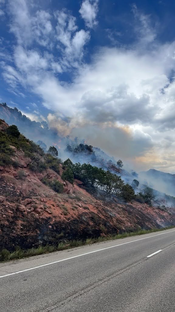
Above average temperatures and dry conditions with no relief from rain in the forecast

GCSO PRESS RELEASE
June 9, 2026

The Garfield County Sheriff’s Office, Bureau of Land Management (BLM), and the seven fire districts in Garfield County are implementing Stage 1 Fire Restrictions effective at 1 a.m., Wednesday June 10, 2026. This applies to all of Garfield County.

This decision was made with thoughtful consideration. We look at the data, the potential for significant wildfires and balance it with the impacts to our community. Our concern, with the level of fire danger we are seeing; one spark could quickly spread into a dangerous wildfire threatening lives, property and natural resources.

Fire restrictions are implemented based on specific criteria to include moisture content of vegetation, weather outlooks, human risk factors, recent fire behavior witnessed over the past week and firefighting resource availability. It has been hot, dry, and unseasonably windy. So far this year, we have had several Red Flag Warnings. The National Weather Service is forecasting above average temperatures and dry conditions with no relief from rain anytime soon.

With increasingly dry vegetation, severe drought conditions, and more hot and dry conditions approaching, the danger for human caused wildfires increases even more.

What Stage I Fire Restrictions mean in Garfield County

  • Fireworks are not allowed under Stage I Fire Restrictions. Professional fireworks shows may be allowed through the permitting process.
  • All burn permits are postponed/Canceled until further notice.
  • Campfires are only allowed within designated fire grates in Developed Areas (i.e. a permanent in-ground containment structure or store-bought fire pit) A temporary fire pan and rock campfire rings will not be acceptable.
  • No fires of any type including charcoal in undeveloped areas.
  • No smoking except within a designated area, enclosed vehicle or building, a developed area or in an area free of combustibles.
  • No use of fireworks or explosive materials, including “exploding” targets or bullets and tracer rounds.
  • Exercise common sense and industry safety practice when welding or operation of an acetylene or other similar torch with open flame always cleared safe area of vegetation and combustibles.

Penalties
Causing a fire during fire restrictions can be a class 6 felony and can be punishable by fines. Other possible charges range from a Class 2 Felony to a petty offense depending on the value of the damage caused. You may be held financially responsible for damage caused.

Federal lands
The use of fireworks, flares, or other incendiary devices, including exploding targets, are always prohibited on federal lands.

By definition:
A “developed area” is an area, whether within city limits or rural, that is groomed, manicured and or watered, where grasses, brush and trees are regularly attended to by land owner. This includes residential and business areas, improved recreational areas, parks and other common areas.

An “undeveloped area” are lands that are not groomed, manicured, or watered, where grasses, brush and trees have been allowed to grow in a natural environment. This includes green belts that are not landscaped or manicured, open space lands, non-manicured park lands, and other areas where the fire hazard presented by the vegetation is determined by the authority having jurisdiction or designee to be an undue wildland fire hazard.

Stage 1 Fire Restrictions begin June 10, 2026

GSFD: I-70 closed at MM112 due to a brush fire

Glenwood Springs Fire Department

June 9, 2026, 4:07 p.m. – This fire has been named the Paradise Fire and is estimated at 20 acres. Two helicopters and two fixed-wing aircraft are en route to assist with suppression efforts. Aircraft will be refilling bucket drops from the Colorado River. I-70 will remain closed at this time.

Firefighters respond to a brush fire in South Canyon near Glenwood Springs.

Firefighters respond to a brush fire in South Canyon near Glenwood Springs.

Firefighters respond to a brush fire in South Canyon near Glenwood Springs.

Firefighters respond to a brush fire in South Canyon near Glenwood Springs.

Firefighters respond to a brush fire in South Canyon near Glenwood Springs.

Firefighters respond to a brush fire in South Canyon near Glenwood Springs.

Firefighters respond to a brush fire in South Canyon near Glenwood Springs.

Photos courtesy of Glenwood Springs Fire Department

Garfield County Emergency Communications Authority

June 9, 2026, 3:15 p.m. – Both directions of I-70 are now closed at the 112 milepost.

Glenwood Springs Fire Department

June 9, 2026, 3:02 p.m.Glenwood Springs Fire Department is responding to a brush fire on westbound I-70 at milepost 112 in South Canyon. Colorado River Fire Rescue is responding in mutual aid. I-70 westbound is being closed at milepost 112.

Garfield County Emergency Communications Authority

June 9, 2026, 3:06 p.m. – I-70 is closed at mile-marker 112 WB, South Canyon, due to a fire.

Glenwood Springs Fire Department
Glenwood Fire website | facebook: #GlenwoodSpringsFireDepartment

GSFD: I-70 closed at MM112 due to a brush fire

Grand Valley Fire Protection District: brush fire west of CR 339/CR300

The Samson Mesa Fire near Keinath Ranch.

Grand Valley Fire Protection District

June 8, 2026, 3:44 p.m. – Samson Mesa Fire, a brush fire to the west of County Road 339/County Road 300, in the area of Keinath Ranch. Crews are currently on scene battling the blaze. Air support is also on scene. We will update when additional information is available. Thank you.

Grand Valley Fire Protection District
Grand Valley Fire website | facebook: Grand Valley Fire Protection District

Grand Valley Fire Protection District: brush fire west of CR 339/CR300

NWS: Red Flag Warning for Garfield County

National Weather Service

June 5, 2026, 10:47 a.m. – The National Weather Service in Grand Junction has issued a Red Flag Warning below 8,000 feet for gusty winds, low relative humidity and dry fuels, which is in effect from 10 a.m. to 10 p.m. MDT Sunday. A Fire Weather Watch has also been issued. This Fire Weather Watch for gusty winds, low relative humidity and dry fuels is in effect from Monday morning through Tuesday evening.

  • AFFECTED AREA: In Colorado, Fire Weather Zone 205 Colorado River Headwaters below 8,000 feet.
  • TIMING: For the Red Flag Warning, from 10 a.m to 10 p.m. MDT, Sunday. For the Fire Weather Watch, from Monday morning through Tuesday evening.
  • WINDS: Southwest 20 to 30 mph with gusts up to 55 mph.
  • RELATIVE HUMIDITY: 11 to 16 percent.
  • IMPACTS: Elevated fire danger is expected. Fires will catch and spread rapidly and erratically.

Precautionary/preparedness actions

A Red Flag Warning means that critical fire weather conditions are either occurring now, or will shortly. A combination of strong winds, low relative humidity, and warm temperatures can contribute to extreme fire behavior.

A Fire Weather Watch means that critical fire weather conditions are forecast to occur. Listen for later forecasts and possible Red Flag Warnings.

NWS: Red Flag Warning for Garfield County

GSFD / CDOT: I-70 westbound – right lane closed near No Name for fire activity

White River National Forest

Crews expect full containment tonight on the two-acre Devil’s Hole Creek Fire, mile 123.4 in Glenwood Canyon. Firefighters have stopped the fire’s growth.

Great coordinated effort with federal, state and local resources. The other two fires mentioned below are named the Shoshone Fire (123.2), which is contained and estimated at two acres, and Grindstone Fire (119.5) which was contained at 0.1 acre by Glenwood Springs Fire Department.

White River National Forest
White River National Forest | facebook #WhiteRiverNF facebook

Glenwood Springs Fire Department

6:05 p.m. UPDATE: The 119.5 and 123.2 fires are contained. The 123.4 fire is more than 50% contained. Crews will remain on scene and continue to work the fires. Command has been turned over to U.S. Forest Service – White River National Forest.

A special thank you to Defiance Rafting and Blue Sky Adventures for providing rafts that allowed firefighters to safely access the fire across the Colorado River. We appreciate their support and partnership. – Glenwood Springs Fire Department

_______________________________________________________________________

3:52 p.m. UPDATE:   A third fire has been located at milepost 123.2.  All three fires are south of the Colorado River near the railroad tracks.  A helicopter is conducting bucket drops.

_______________________________________________________________________

3:40 p.m. UPDATE:  An additional spot fire has been located adjacent to the railroad tracks near milepost 123.4.

_______________________________________________________________________

Shortly after 3:00 p.m., firefighters were dispatched to a reported brush fire on the south side of the Colorado River near mile marker 119.5 eastbound on I-70 in Glenwood Canyon.

Upon arrival, crews located a small brush fire burning in sagebrush. A Type 3 helicopter has been requested to assist with water bucket drops.  

For firefighter safety, the slow (right) eastbound lane of I-70 has been closed in the area. Motorists are encouraged to use caution, reduce speeds, and watch for emergency personnel working along the roadway.

Additional updates will be provided as information becomes available. Photos courtesy of Glenwood Springs Fire Department.

Glenwood Springs Fire Department

Glenwood Fire website | facebook: #GlenwoodSpringsFireDepartment

Glenwood Springs Fire Department - fire activity

A brush fire burns in Glenwood Canyon.

A U.S. Forest Service truck and a Glenwood Springs Fire Department fire truck on the scene of a brush fire in Glenwood Canyon, near Glenwood Springs, CO.

Colorado Department of Transportation

Right lane closed. Updated today at 3:52 PM MDT by Colorado Department of Transportation

Between exit 121: Grizzly Creek and exit 119: No Name (near No Name) at Mile Point 119.5. The right lane is closed due to fire activity. Slower speeds are advised.

Comment: Right lane closed ahead use caution

Colorado Department of Transportation
COtrip website

GSFD / CDOT: I-70 westbound – right lane closed near No Name for fire activity

GSPD and Garco911: 7th St and Bennett police presence

Glenwood Springs Police Department and Garfield County Emergency Communications Authority

5.21.26, 7:20 p.m. – 7th Street & Bennett Avenue: The area is now clear. There’s no ongoing threat. Residents can resume normal activity.

Departamento de PolicĂ­a de Glenwood Springs y Autoridad de Comunicaciones de Emergencia del Condado de Garfield

5.21.26, 7:20 p.m. – Calle 7 y Avenida Bennett: La zona ya está despejada. No existe ninguna amenaza. Los residentes pueden retomar sus actividades normales.

Glenwood Springs Police Department and Garfield County Emergency Communications Authority

5.21.26, 6:40 p.m. – 7th Street and Bennett Avenue – Glenwood Springs: There is a law enforcement presence in the area. Please stay inside, lock doors and windows or avoid the area.

Glenwood Springs Police Department facebook

Presencia policial

5.21.26, 6:40 p.m. – 7th St y Bennett Ave, Glenwood Springs: Hay presencia policial. Por favor, permanezca adentro, cierre con llave las puertas y ventanas, y evite el área.

Glenwood Springs Police Department facebook

GSPD and Garco911: 7th St and Bennett police presence

Xcel Energy / City of Glenwood: Power outage

Xcel Energy

UPDATED: restoration time for some or all customers 10:00 p.m., 5/16/2026

Type: Known electric outage

Comments: The outage has been reported. Please continue to check back for additional updates regarding the restoration progress.

Time off: 3:44 p.m., 5/16/2026

Xcel Energy outage map

City of Glenwood

5.16.26, 3:31 p.m. – We’re aware of the power outage currently affecting Glenwood Springs, New Castle, and Silt. Xcel Energy is actively working to restore service as quickly as possible.

At this time, please do not call the electric company to report the outage, as they are already aware of the issue and responding.

We appreciate your patience and will share updates as they become available.

City of Glenwood facebook page

Xcel Energy / City of Glenwood: Power outage

CRFR press release: Passenger train and tanker truck collide between Rifle and Silt, Colorado

Colorado River Fire Rescue

At approximately 9:39 a.m. this morning, Colorado River Fire Rescue (CRFR) was dispatched to a reported collision involving a passenger train and a tanker truck between Silt and Rifle, Colorado.

CRFR responded with two engines, two ambulances, and a Battalion Chief. Upon arrival, crews found a passenger train involved in a collision with a tanker truck carrying hot asphalt tar. The collision resulted in the derailment of the train.

The driver of the tanker truck sustained minor to moderate injuries and was transported by ambulance for medical evaluation. No additional patients required transport.

CRFR personnel assisted approximately 310 passengers and train staff members from the train to waiting buses for transportation to their final destination.

Multiple agencies assisted with the incident response, including the Garfield County Sheriff’s Office, Colorado State Patrol, Colorado Department of Transportation, New Castle Police Department, and Union Pacific personnel.

The incident remains under investigation by the appropriate authorities.

Leif Sackett
Fire Chief
Colorado River Fire Rescue

Colorado River Fire Rescue
CRFR website | facebook: #ColoradoRiverFireRescue

CRFR press release: Passenger train and tanker truck collide between Rifle and Silt, Colorado

Garco911 / CDOT: Highway 6 reopened east of Rifle

Garfield County Emergency Communications Authority and Colorado Department of Transportation

5.6.26, 5:10 p.m. – Highway 6 is open at Mile Pond Road, both directions, east of Rifle.

Colorado Department of Transportation is strongly discouraging travel on Highway 6 tonight due to active work crews in the area.

Garco911 / CDOT: Highway 6 reopened east of Rifle

CSP: Train derailment following crash on Highway 6

Colorado State Patrol

May 6, 2026, 12:12 p.m. – This morning, around 9:40 a.m., the Colorado State Patrol responded to the area of Highway 6 near Mile Pond Road (milepost 95) for a report of a passenger train that struck a semi-tanker truck on the train tracks.

The semi-tanker was split open due to the crash, spilling an estimated 6,000 gallons of road oil onto the ground. The driver of the semi-tanker was taken to an area hospital for minor injuries. Six passenger cars and two locomotives were derailed as a result of the crash, with the rail being damaged/split in areas. The rail line will be closed for an extended period of time for repairs. It is unknown at this time how many passengers were on the train; however, it is reported that no passengers suffered any injuries. Local buses will be transporting passengers to a safe location.

Highway 6 will be closed for an extended period of time. For road closure information, please visit COTrip.org for more information.

The Colorado State Patrol is the lead investigating agency for this incident. Any new information will be released in an update to this press release.

A Colorado State Patrol photograph of the tanker and train collision near Rifle on May 6, 2026.

A Colorado State Patrol photograph of the tanker and train collision near Rifle on May 6, 2026.

A Colorado State Patrol photograph of the tanker and train collision near Rifle on May 6, 2026.

A Colorado State Patrol photograph of the tanker and train collision near Rifle on May 6, 2026.

A Colorado State Patrol photograph of the tanker and train collision near Rifle on May 6, 2026.
CSP: Train derailment following crash on Highway 6