12.2.25, 8:47 p.m. – I-70 is open at mile marker 90 eastbound, RIFLE.
12.2.25, 7:29 p.m. – I-70 is closed at mile marker 90 eastbound, RIFLE, due to an accident.
REGISTER for emergency alerts at garco911.com
SUBSCRIBE for emails from this feed - click at upper right
VIEW: Inciweb wildfires | CDOT routes | NOAA storms | CAIC avalanches
Garfield County | Accessibility
12.2.25, 8:47 p.m. – I-70 is open at mile marker 90 eastbound, RIFLE.
12.2.25, 7:29 p.m. – I-70 is closed at mile marker 90 eastbound, RIFLE, due to an accident.
12.2.25, 8:56 p.m. – I-70 is open at mile marker 97 westbound, Silt.
12.2.25, 7:27 p.m. – I-70 is closed at mile marker 97 westbound, SILT, due to an accident.
December 2, 2025, 11:28 a.m. – Westbound Interstate 70 is open at mile marker 121, Grizzly Creek.
December 2, 2025, 11:16 a.m. – Westbound Interstate 70 is closed at mile marker 121, Grizzly Creek, due to an accident.
December 2, 2025, 11:15 a.m. – I-70 is now open at mile marker 105, New Castle.
December 2, 2025, 9:27 a.m. – Eastbound Interstate 70 is closed at mile marker 105, just before the New Castle exit, due to an accident. Traffic is being diverted at Silt.
10.16.25, 9:35 am – Hwy 82 is open, both lanes, at mile-marker 13 EB, 2 miles east of Carbondale.
10.16.25, 9:17 am – Hwy 82 has one lane open at mile-marker 13 EB, 2 miles east of Carbondale, due to an accident.
10.16.25, 8:22 am – Hwy 82 is closed at mile-marker 13 EB, 2 miles east of Carbondale, due to an accident.
9.27.25, 12:15 pm – I-70 is open at mile marker 133 westbound, Dotsero.
9.27.25, 10:33 am – I-70 is closed at mile marker 133 westbound, Dotsero, for additional work from last night’s accident. Unknown time to reopening.
9.27.25, 12:40 am – I-70 is open at mile marker 130 westbound, Dotsero.
9.26.25, 9:03 pm – Westbound I-70 is closed to through traffic at Wolcott, Exit 157, due to a rolled over CMV crash that took place in Glenwood Canyon at around 6 p.m. this evening. CDOT and its partners worked tirelessly to avoid putting a detour in place — estimated to add four hours of travel time — but unfortunately, I-70 through Glenwood Canyon is an extremely challenging section of road with limited space for operations. There is no estimated time of re-opening.
The detour that is in place directs commuters onto US 6 via exit 157, Wolcott, north on HWY 131 toward Steamboat, west on US 40 towards Craig, south on HWY 13, and back on I-70 near Rifle.
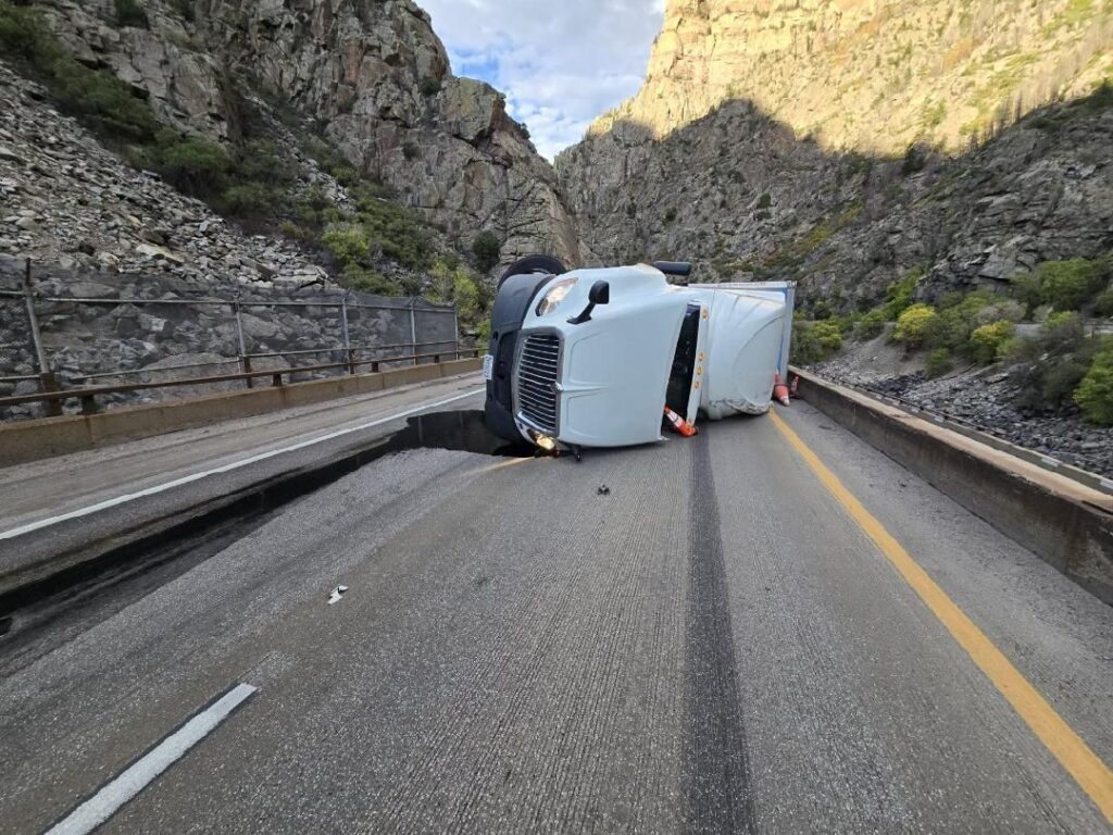
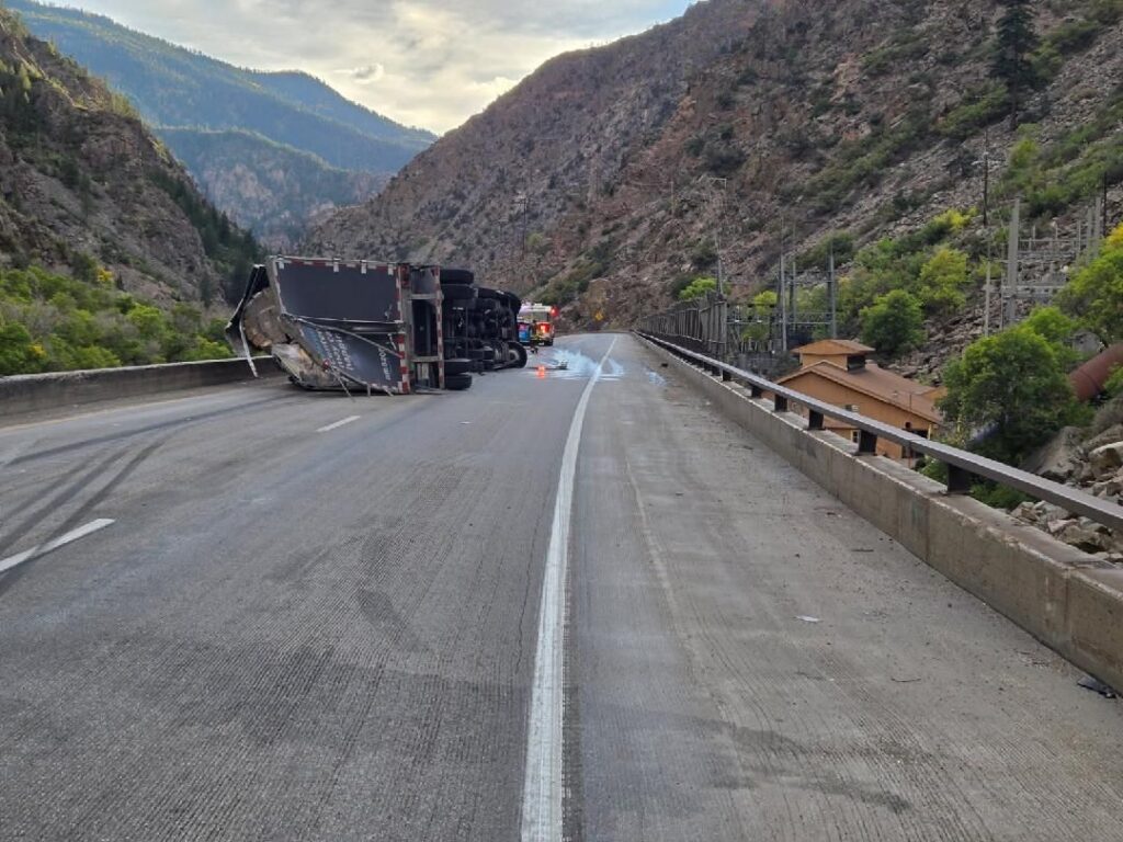
Check COtrip.org or the #COtrip Planner app for more information and road updates.
9.26.25, 6:00 pm – I-70 is closed at mile marker 130 westbound, Dotsero, due to an accident.
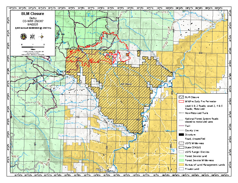
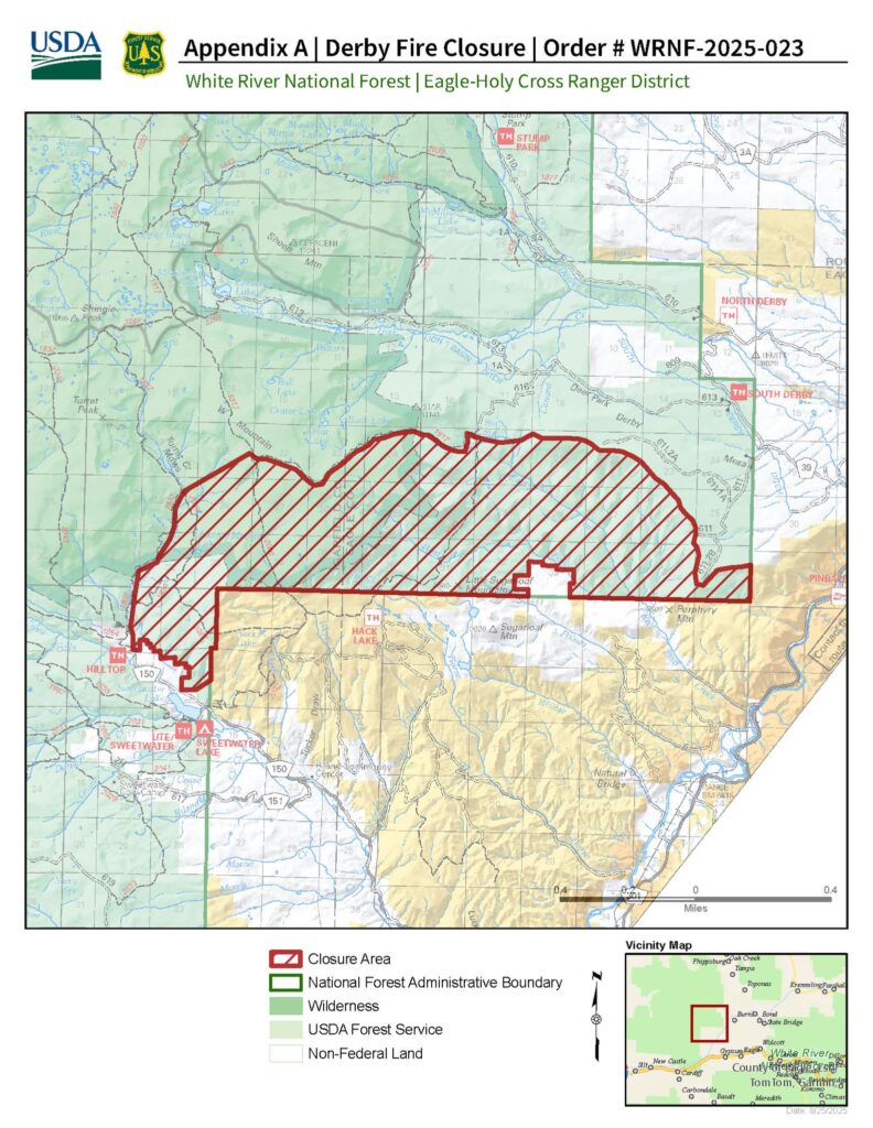
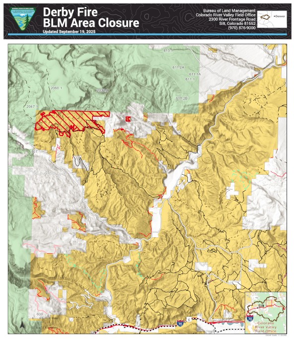
The Bureau of Land Management has reopened more public lands in Garfield and Eagle counties that were previously closed due to the Derby Fire. The updated closure order takes effect immediately.
Some areas inside the burned perimeter remain closed because they’re not safe. There are hazards like burned trees and ongoing work to repair damage from fighting the fire. See below and attached map for details. The closure order and map are also available on the BLM website.
This closure affects: BLM lands north and west of the town of Gypsum, Colorado, that are north of Sweetwater Road; west of the Colorado River; east of the White River National Forest boundary; and south of Derby Creek.
BLM issued the emergency closure Aug. 20 to ensure public and firefighter safety during fire suppression efforts and to reduce exposure to hazardous situations because of fire behavior of the Derby Fire.
This order will remain in effect until fire BLM rescinds the order. The public is to remain clear of the areas still closed. Please use caution and watch for firefighters when traveling in the area. Violations of this emergency order may lead to prosecution, with fines and possible imprisonment.
Thank you for your understanding as we focus on public safety and protecting natural resources.
For questions about the land closure, call the Colorado River Valley Field Office at 970-876-9000. For updates on the Derby Fire, visit the U.S. Forest Service White River National Forest page on Facebook.
The Derby fire is now 70% contained, but despite the fire activity lessening, it is still important to remember that this is an active fire. There is still a significant amount of firefighter traffic and work occurring, and the closures remain in place for the safety of both firefighters and the public.
For more information on the closures for Bureau of Land Management visit: https://www.blm.gov/ucr-fire-restrictions
For more information on the closures on the White River National Forest visit: https://www.fs.usda.gov/r02/whiteriver/alerts/